| Olive Through the Ages
Historical
descriptions | Maps
and photos | Olive boundaries
_____________________________________________________________________________
When I first began studying the history of Olive, I believed
Olive only existed around the Olive Heights area. But historian Gordon
McClelland enlightened me to the fact that during the citrus growing
years Olive once extended out to "Batavia Street on the east Anaheim
side, Taft on the Orange side, Santiago on the Villa Park side, the
Santa Ana River on the Yorba Linda side, and out a little into Santa
Ana Canyon Road this side of the Santa Ana River, up to where the Santa
Ana Canyon Road meets Imperial Highway."
Historians Chris Jepsen and Susan Berumen of the Orange County Archives,
and Orange County historian Phil Brigandi helped further my knowledge
about Olive's boundaries. Chris showed me where landowner James R. Toberman's
Olive Tract existed in 1883, and Phil identified the location of the
nearby St. James town tract of 1887. Susan located the oversized books
containing these historic maps and let me photograph them.
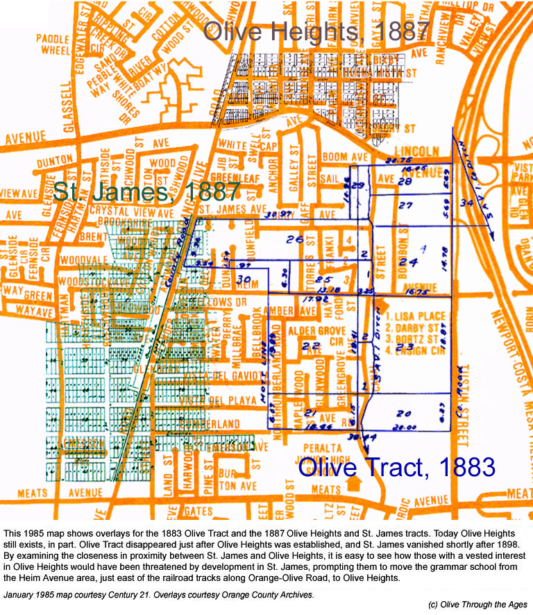
After doing some analysis of all three tracts and their closeness in
proximity, I came to better understand how and why Olive progressed
in the manner and direction as its history played out.
My thanks to Gordon, Chris, Susan, and Phil for sharing this vital information
about Olive's history. Thanks also to Tom Pulley for sharing Mary McClelland's
1920s post card showing a view of Olive looking north of Santa Ana Canyon
Road.
I would like to add that Chris inspired me to create map overlays showing
a particular location at two or three different points of time, in one
image. These map images are accessible by clicking/tapping the thumbnail
images in the section below to view larger images in a separate browser
window or tab. - Daralee

Olive boundaries from 1876 to present
times

|
|
| 1883 Olive Tract |
|
| |
|
 |
|
| 1887 Olive Heights tract |
|
| |
|
 |
|
| 1887 St. James tract |
|
| |
|
 |
|
| Olive tract, Olive Heights, and St.
James |
|
| |
|
 |
|
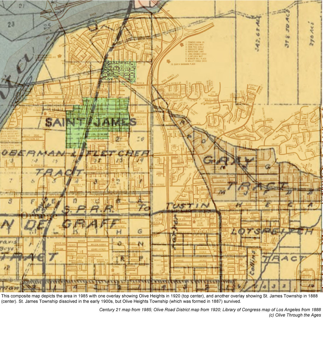
| St. James & Olive, 1888 |
|
| |
|
 |
|
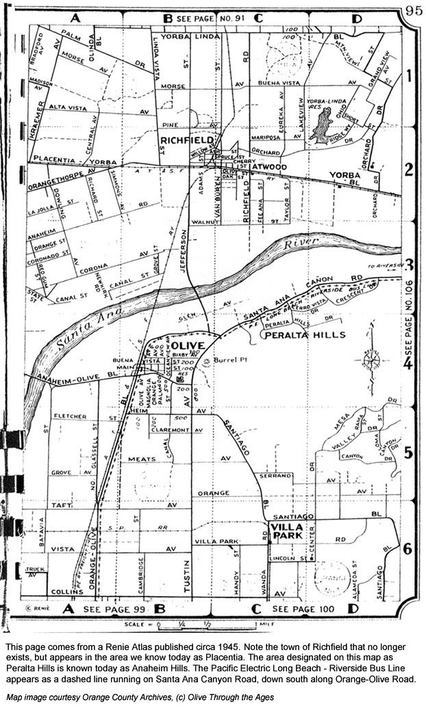
| Circa 1945 map of Olive area |
|
| |
|
 |
|
| 1948 map of Olive and
Orange area |
|
| |
|
 |
|
| Click/tap the image to view a slide
show of Olive's boundaries from the 1910s to 1960s with a narrative
by Gordon McClelland |
|
| |
|
Along with its changing definition as a town, the boundaries
of Olive also changed considerably throughout its history.
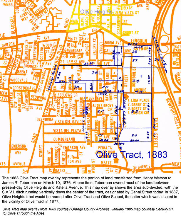
On March 10, 1876 landowner James R. Toberman—who at one time
owned most of the land between present day Olive Heights and Katella
Avenue—established Olive tract a half mile south where Olive Heights
tract would exist 11 years later. In May 1883 Olive tract was roughly
bordered by the following streets we recognize today: St. James Avenue
and Lincoln Avenue to the north, Orange-Olive Road and Northumberland
Road to the west, Heim Avenue and Cumberland Road to the south, and
Tustin Street to the east.
Olive tract ceased to exist when Toberman sold his land at the end of
December 1888, about a year after Olive Heights tract was established
by the Olive Milling, Land & Improvement Company. The new tract,
a half mile north of Olive tract, was insured a measure of success with
its profitable Olive Milling Company flour mill having been in operation
since 1882.
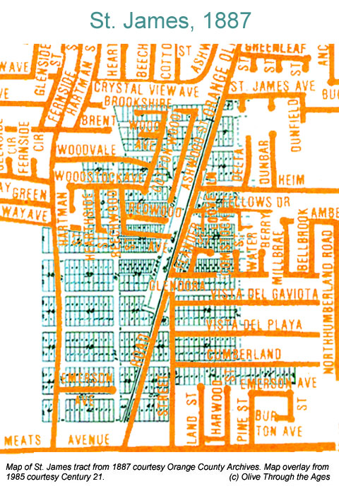
Still Olive Heights stakeholders felt threatened by the neighboring
town of St. James which also sprung up in 1887. And no wonder; the area
of St. James was twice the size of Olive Heights and St. James was constantly
being touted by Pacific Land Improvement Company developers in glowing—if
not highly exaggerated—press advertisements. However, as the sub-divided
plots of land were being auctioned off, The Los Angeles Times
correspondent J. Franklin reported on July 21, 1887 that these two boomtowns
were equals:
These new towns are as closely joined together as the Siamese twins.
Therefore there need be no jealousy on the part of either, as improvement
in one is a benefit to the other and vice versa. Olive Heights is at
the mouth of Santa Ana Cañon, and has most beautiful residence
as well as good business locations, and will undoubtedly retain the
postoffice, while the depot, which is half a mile away, will be located
at St. James.
Though Olive had an edge over St. James with its profitable flour mill
being advertised as the most important manufacturer in Orange County,
Olive Milling, Land & Improvement Company took extra measures to
ensure its town's survival and secured the railroad depot in 1890. In
1893 they had the grammar school moved from Olive tract to Olive Heights.
By the turn of the century, St. James no longer posed a threat to Olive
Heights when landowners realized St. James' water supply was not as
they had been promised.
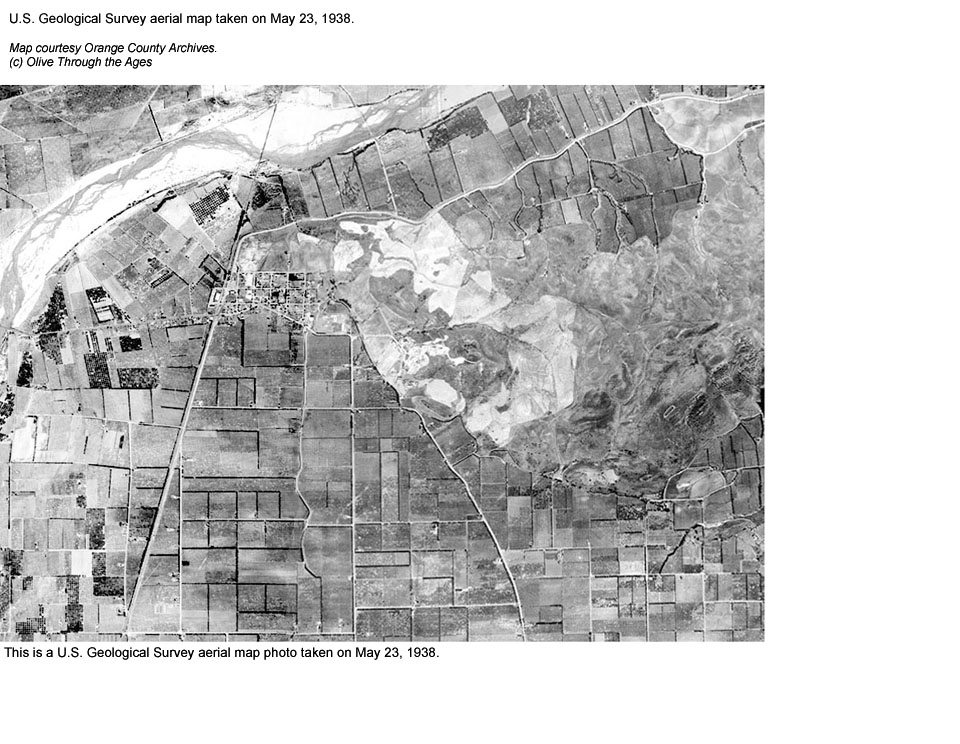
Around 1900 the climate and soil in Olive was becoming known for producing
superb crops, and in the early 1920s citrus fruit growing became the
dominant industry in Olive, eclipsing that of the now fading Olive flour
mill. As ranchers purchased acres upon acres of land for planting and
cultivating citrus groves and other crops, the boundaries of Olive began
to expand far beyond the Olive Heights tract. Within the next decade
a patchwork of groves covered the area then known as Olive up to the
Santa Ana River, across to Imperial Highway, down to Villa Park Road,
and over to Main Street.
By the late 1950s real estate became increasingly more valuable in Southern
California and ranchers began selling their land to developers. In the
early 1960s citrus groves began to disappear, replaced by housing tracts.
While the Southland was changing from a rural to a suburban environment,
much of the acreage between Olive and Orange was annexed to the City
of Orange. By the late 1960s the boundaries of Olive were significantly
reduced, having been scaled back to the original Olive Heights tract
area.
Today Olive is a residential island within the Olive Heights tract area
of 1887, with pockets of that area now a part of the City of Orange.
Sources: All maps courtesy Orange County Archives, except
1948-49 Jay Gee Business Directory map courtesy Orange Public Library
HIstory Center; "Olive Heights and St. James" article by J.
Franklin from the July 21, 1887 edition of Los Angeles Times, ProQuest
Historical Newspapers; "New Block Is Planned For Olive" article
from the February 25, 1923 edition of Los Angeles Times, ProQuest Historical
Newspapers; "Lost Cities: Swallowed up like Atlantis, they yet
linger in memory's heart" article by Philip Hindley, published
in December 1980 edition of Orange County Illustrated.
Views of Olive from 1883 to 1945

|
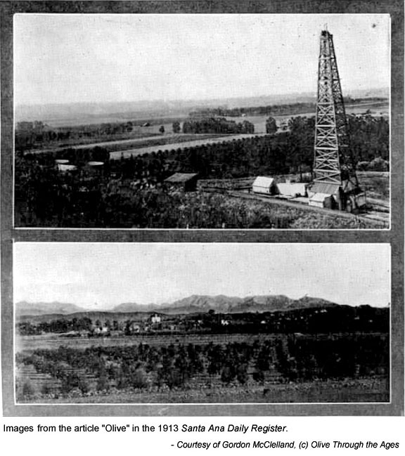
Oil well and fields in Olive (Source: Santa Ana Daily Register,
1913)
|
|

|
C.P. Taft's loquat groves in Olive (Source: Santa Ana Daily Register,
1913) |
| |
|
|
|
|
 |
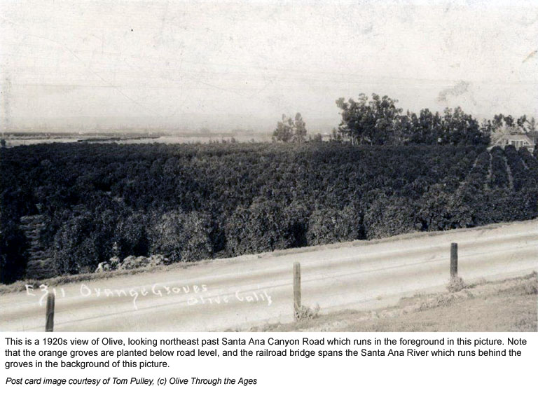
Post card photo
of groves in Olive from the 1920s (Source: Tom Pulley) |
|
 |
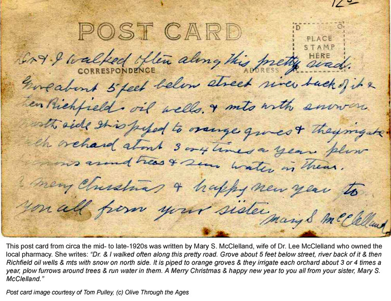
Reverse side
of post card with note from the mid- to late 1920s written by Mary
McClelland (Source: Tom Pulley) |
| |
|
|
|
|
 |
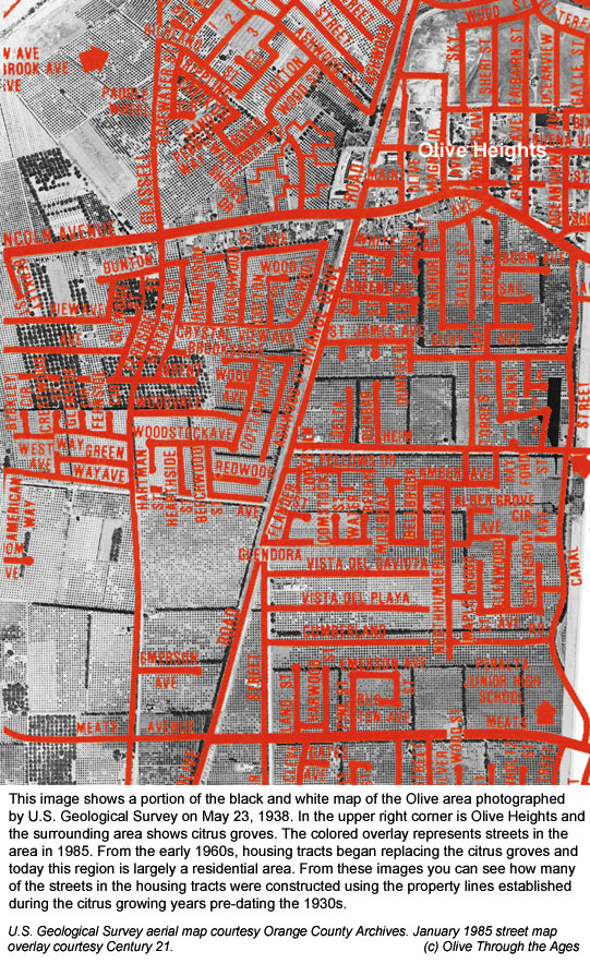
1938 U.S. Geological
Survey aerial map of Olive with 1985 map overlay (Source: OC Archives) |
|
 |
1883 Olive
tract map and circa 1945 Renié Atlas map overlays over 1985
map (Source: OC Archives) |
| |
|
|
|
|
|