| Olive Through the Ages
Brick
yard & tile co. | Bank
of Olive | Olive
Garage | Olive
Hotel & Motel | Olive
Mill | Other
_____________________________________________________________________________
Remembrances of
the 'Brick Yard' during the 1960s - by Gordon McClelland
These remembrances were compiled from several
email messages Gordon McClelland sent me describing the "Brick
Yard" he remembered as a youth during the 1960s. My comments appear
in non-italicized text or between brackets [ ]. - Daralee
Please note that clicking/tapping icons or links in the text below opens
images or pages in separate browser windows or tabs.

As a kid I was skateboarding down Ocean
View street nearly every afternoon and hanging out around what we called
the "Brick Yard." They were making red clay pipes and red
tile for roofs. The pipes and tiles were stacked high and there were
trucks and other equipment sitting around. Everything was covered with
red clay dust. There were some old, dilapidated buildings and large
pepper trees surrounding the place. I'm not absolutely sure, but I think
I recall seeing a sign at the Brick Yard that said "Mission Clay
Company." [Click/tap here
to view a 1967 image of the Mission Clay Products Company sign Gordon
saw.]
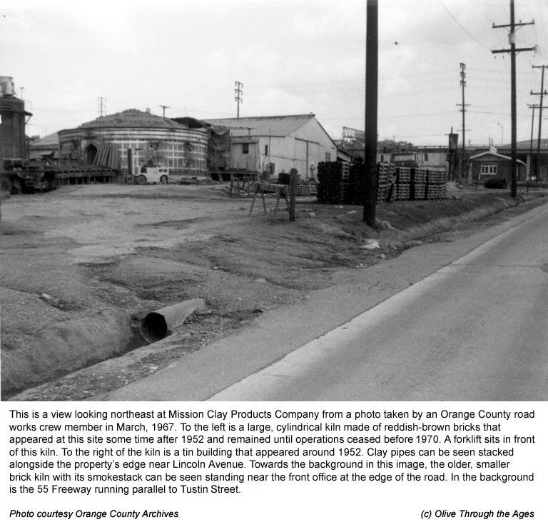
I loved that huge, round furnace they used for firing the clay pipes
and roof tiles. The kiln was made of reddish-brown brick and had slit
type openings in the side. When the furnace was on at night you could
see the intense fire glowing through the slit openings.

|
|
| 1967 photo of the brick yard. |
|
| |
|
After seeing the 1967 image at left (click/tap
here
to view it larger), Gordon had additional comments about the brick yard
site:
The round structure on the left side of photo is the kiln I wrote
you about. It’s hard to see the vent holes in this photo, but
when the kiln was lit up at night you could see the glow of the raging
fire through those holes. It also had a sort of roaring sound, as I
recall. You can see a forklift in the picture which gives you an idea
of the size of the main, round kiln.
The large building next to the kiln looks to be of a tin construction,
which was inexpensive to make and popular after the WWII era. Seems
to me they processed and formed the clay in that building. You can see
they built a makeshift, covered patio type of structure to have a sort
of roof over the area between the tin building and the round kiln. They
undoubtedly loaded and unloaded the kiln from that side.
You can also see the pipes stacked up, as I mentioned, but at the time
this photo was taken, I guess they didn’t have the roof tiles
on hand. At one time, these too would have been stacked up on wooden
pallets in the dirt lot areas you see.

|
|
| Etching by Scott FitzGerald of an
older type of dry kiln at the brick yard |
|
| |
|
There were small kilns located on the
left hand side of this photo near the back of the huge, round kiln.
The small ones in Scott FitzGerald’s etching were nowhere near
as large as the round kiln. [Click/tap here
to view a larger image of this etching of the kiln.]
If you look at Scott’s etching, there are two structures, both
made of brownish-red brick. To the right is an old kiln with an arch
top opening. To the left is a squarish, brick structure with a vent
in the side and a smokestack on top. This would likely be some type
of heating device, probably fueled with oil. The poles and bars around
the kiln were used for support, although by the time Scott got there
they were obviously falling apart.
If you look again at the 1967 photo, towards the top right corner next
to the Mission Clay office building, I think the smokestack you see
is the same one in Scott’s etching. The position of this kiln
lines up with the Sanborn Map's notation of where the old kilns were
located. [Click/tap here
to see an image of the 1929 Sanborn Map.]
Anyway, the round kiln was the only one I recall being in use when I
was a kid. It’s possible the smaller kilns were still being used,
but I just remember them looking like old, broken down structures, pretty
much what you see in Scott's etching.

|
|
| Watercolor by Crandall Norton of brick
yard structures circa 1950 |
|
| |
|
If you look at the Crandall Norton watercolor
[click/tap here
to view a larger image] you will see a flimsy structure of tin and wood
which was gone when the 1967 photo was taken. By the way the artist
talked, that structure was located about where the large, white, tin
building is in the photo. I never saw that structure, but then the watercolor
was painted before I was even born.
Norton couldn’t recall the round kiln, so I never knew when it
was built. It doesn’t look like it was around in 1929 when the
Sanborn Map was made. From the way that map looks, they might have been
sun-drying a lot of the tiles and bricks as opposed to firing them?
Gordon and I later analyzed the U.S. Geological Survey images from 1947
and 1955.
Based on these aerial maps and a 1952 aerial view of the region I generated
at HistoricAerials.com, we learned the large, circular kiln most likely
appeared some time after 1952 but before 1955.
If the 1967 photo would have continued to show more of the area to
the left side of the kiln, you would have seen some large pepper trees
and the dirty, old pond with a broken-down wooden dock going out into
the water about five feet. The pond (reservoir) had slimy sides which
made it nearly impossible to get out if you jumped in the water. We
had a raft we took out to the pond on occasion.
When this area was undeveloped, we would ride our bikes up and down
the rolling dirt hills on the other side of the pond where large trees
gave shade to some areas. When they made it all into a park, they pretty
much left the hills and valleys the same and just planted more trees
and grass. In my opinion, that [Eisenhower] park area of Olive is much
nicer than it was back then.
Notes about the Brick Yard and adobe
structures in the area
Gordon says the dirt and pond water were
undoubtedly used to create the clay bricks, pipes and tiles. The dirt
in this region and many parts of Southern California is very hard and
clay-like, which is why many adobe structures were built here in earlier
times.
Since Mission Clay Products Company was a significant business entity
in the Southland for many decades, it is likely several of the structures
in Olive that appeared in the 1920s up until the 1960s were made of
bricks and tiles manufactured by the Company.
The Gelker Adobe at 16741 Buena Vista Street and Ocean View Avenue was
constructed of adobe brick with a tile roof in 1935. (Click/tap here
to see an image of this home under construction in 1935, and click/tap here
to see an image of this home in 2009.)
Gordon writes in one of his earlier emails: A person you need to
talk to is Bruce Gelker [rancher Ben Gelker's son]. He is older than
me and grew up in Olive. He built and owned the Saddleback Inn in Santa
Ana. In the late 1960s and early 1970s we talked a number of times and
shared stories about Olive and the Brick Yard. At some point he purchased
the property on the corner of Lincoln and Tustin. His original plan
was to design a commercial plaza which included a round brick building
and kept to the basic layout of the old brick yard. As you know, it
didn't turn out that way, but the plaza was called the Brick Yard in
remembrance of the place.
The Olive Volunteer Fire Department building, constructed circa 1946,
was also made of adobe brick with a tile roof. This structure stood
near the northwestern corner of Orange-Olive Road and Lincoln Avenue
until 1997 when the fire department closed and the building was razed
to make room for the construction of condominums. (Click/tap here
to view an image of the Fire Department building in 1982.)
To date, many questions about the once thriving brick yard—that
has long since disappeared—remain unanswered.
Brick yard &
tile co.
|