| Olive
Through the Ages
Click/tap the map below to view it larger.
Click/tap the link (A-K) to go to that section: Main,
A,
B, C,
E, F,
G, H,
I, J,
K
_____________________________________________________________________________
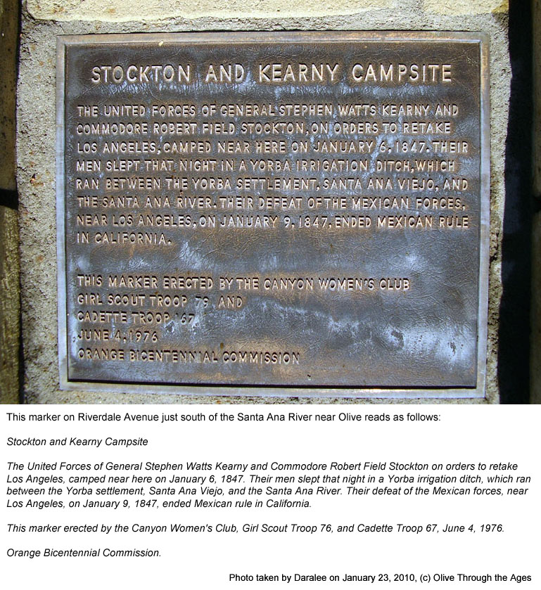
|  Stockton
and Kearny Campsite marker: The plaque [pictured right in
2010] explains that the united forces of Commodore Robert Field
Stockton and General Stephen Watts Kearny camped near the site
of this marker on Riverdale Avenue, west of where Orange-Olive
Road ends, on January 6, 1847, en route to Los Angeles. The soldiers
reportedly slept in one of the irrigation ditches made by the
Yorba family which ran alongside the Santa Ana River. Stockton
and Kearny Campsite marker: The plaque [pictured right in
2010] explains that the united forces of Commodore Robert Field
Stockton and General Stephen Watts Kearny camped near the site
of this marker on Riverdale Avenue, west of where Orange-Olive
Road ends, on January 6, 1847, en route to Los Angeles. The soldiers
reportedly slept in one of the irrigation ditches made by the
Yorba family which ran alongside the Santa Ana River.
|
|
 |
| |
|
|
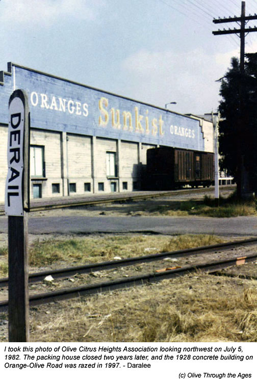
|  Olive
Heights Citrus Association: This building in which the packing
house operated [pictured right in 1982] was constructed of concrete
in 1928 on the western side of the railroad tracks at 104 Railroad
Street (Orange-Olive Road) [see 1929
Sanborn Map] following the destruction of its original wooden
building by fire at the site across the street [see 1922
photo]. Olive
Heights Citrus Association: This building in which the packing
house operated [pictured right in 1982] was constructed of concrete
in 1928 on the western side of the railroad tracks at 104 Railroad
Street (Orange-Olive Road) [see 1929
Sanborn Map] following the destruction of its original wooden
building by fire at the site across the street [see 1922
photo].
The last citrus packing house to remain in Olive,
operations ceased in 1984 after the company merged with the Olive
Heights Citrus Association plant in Corona. In 1987, the property
was sold to a developer. Fire gutted the structure in December
1988, and the building was razed in 1997. |
|
 |
| |
|
|
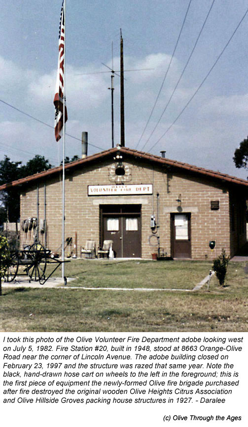
 Olive
Volunteer Fire Department: This adobe brick building, built
in 1948 [pictured right in 1982], stood near the northeastern
corner of Railroad Street (Orange-Olive Road) and Anaheim-Olive
Boulevard (Lincoln). Olive
Volunteer Fire Department: This adobe brick building, built
in 1948 [pictured right in 1982], stood near the northeastern
corner of Railroad Street (Orange-Olive Road) and Anaheim-Olive
Boulevard (Lincoln).
As the town of Olive began to diminish over time,
nearly all the original response area of Olive VFD was annexed
into neighboring cities. In 1987, the property was sold to a developer.
Fire Station 20 was deactivated in 1996, and the building razed
in 1997.
Thankfully, my sister suggested I capture the images
of the Sunkist packing house and fire station on film using her
Pentax camera. She sadly, and correctly, believed that one day
these buildings would disappear forever. |
|
 |
| |
|
|
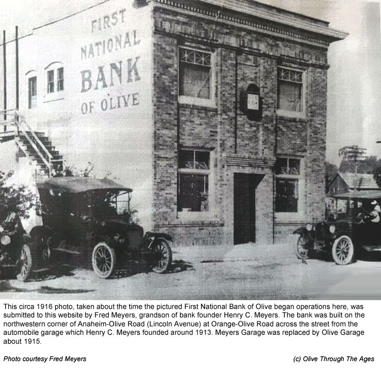
 First
National Bank of Olive: This building, constructed by the
order of Henry C. Meyers in 1916 [pictured right circa 1916],
sat on the northwestern corner of Anaheim-Olive Blvd. (Lincoln
Ave.) at Railroad Street (Orange-Olive Road). The bank operated
out of this building until it closed in 1933. The building was
used for other operations until it was razed in 1966 due to the
realignment of Lincoln Avenue. First
National Bank of Olive: This building, constructed by the
order of Henry C. Meyers in 1916 [pictured right circa 1916],
sat on the northwestern corner of Anaheim-Olive Blvd. (Lincoln
Ave.) at Railroad Street (Orange-Olive Road). The bank operated
out of this building until it closed in 1933. The building was
used for other operations until it was razed in 1966 due to the
realignment of Lincoln Avenue.
|
|
 |
| |
|
|
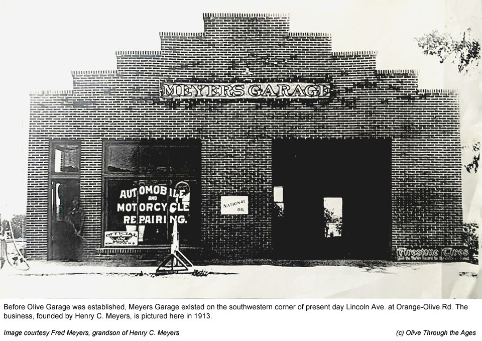
 Meyers Garage: About 1913, Henry C. Meyers started this business
in the brick building [pictured right in 1913] on the southwestern
corner of Anaheim-Olive Blvd. and Railroad Street.
Meyers Garage: About 1913, Henry C. Meyers started this business
in the brick building [pictured right in 1913] on the southwestern
corner of Anaheim-Olive Blvd. and Railroad Street.
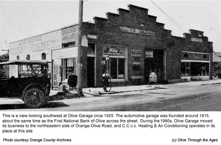
Olive Garage:
A couple of years later, the Olive Garage business replaced Meyers
Garage at this site. The brick building [pictured right circa
1925] still stands today at 606 E. Lincoln Avenue in Orange, occupied
by C.C.c.c. Heating & Air Conditioning since around October
1983. The Olive Garage business completely relocated
to 2845 Orange-Olive Road in 1984, where it continues to operate
today in the modified 1920s gas station building. |
|
|
| |
|
|
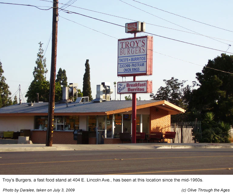
 Troy's
Burgers: This building at 204 E. Lincoln
Ave. [pictured right in 2009] was constructed in the mid-1960s and
continues to be used by Troy's Burgers today. Troy's
Burgers: This building at 204 E. Lincoln
Ave. [pictured right in 2009] was constructed in the mid-1960s and
continues to be used by Troy's Burgers today. |
|
 |
| |
|
|
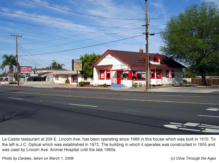
 La
Casita Restaurant: This house constructed in 1910 [pictured
right in 2009] on the north side of Lincoln Ave. has been used for
business purposes by La Casita restaurant since 1988. The diner
continues to operate at 209 E. Lincoln Ave. La
Casita Restaurant: This house constructed in 1910 [pictured
right in 2009] on the north side of Lincoln Ave. has been used for
business purposes by La Casita restaurant since 1988. The diner
continues to operate at 209 E. Lincoln Ave. |
|
 |
| |
|
|
 Lincoln
Ave. Animal Hospital: The rectangular-shaped building constructed
on the north side of Lincoln Ave. in 1955 was used by Lincoln
Ave. Animal Hospital through the late 1960s. [Signage for the
business is pictured top right in February 1967.] Note the house
next door to the pet clinic; this structure would also be used
for business operations by La Casita Restaurant about 20 years
later. Also, further down the road, on the south side of Lincoln
Ave. is Troy's Burgers. These two businesses remain at their respective
locations today. Lincoln
Ave. Animal Hospital: The rectangular-shaped building constructed
on the north side of Lincoln Ave. in 1955 was used by Lincoln
Ave. Animal Hospital through the late 1960s. [Signage for the
business is pictured top right in February 1967.] Note the house
next door to the pet clinic; this structure would also be used
for business operations by La Casita Restaurant about 20 years
later. Also, further down the road, on the south side of Lincoln
Ave. is Troy's Burgers. These two businesses remain at their respective
locations today.
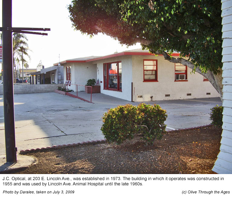
After Lincoln Ave. Animal Hospital left this
site, J.C. Optical [pictured bottom right in 2009] began operating
out of this building at 203 E. Lincoln Ave. in 1973 and remains
here today. |
|
|
| |
|
|
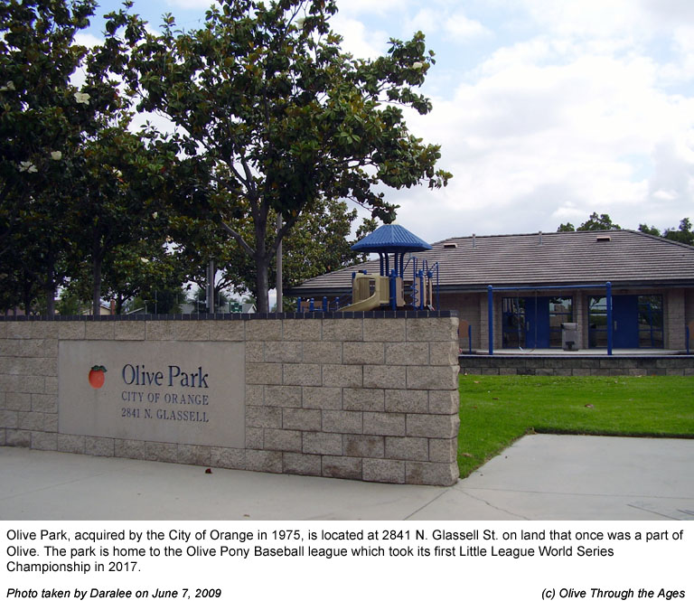
 Olive
Park: Land for the park at 2841 N. Glassell St. [pictured right
in June 2009] was acquired by the City of Orange in 1975. The park
is home to the Olive Pony Baseball league which took its first Little
League World Series championship in 2017. Olive
Park: Land for the park at 2841 N. Glassell St. [pictured right
in June 2009] was acquired by the City of Orange in 1975. The park
is home to the Olive Pony Baseball league which took its first Little
League World Series championship in 2017. |
|
 |
| |
|
|
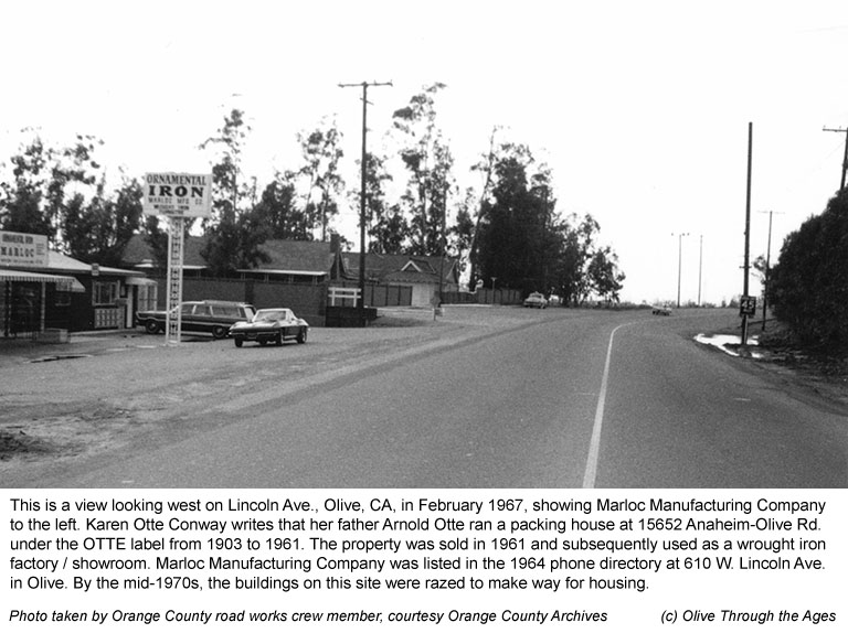
 Marloc
Manufacturing Co.: This is a view looking west on Lincoln Ave.
[pictured right in February 1967] towards the bridge over the Santa
Ana River. To the left is the Marloc Manufacturing Co. wrought iron
factory / showroom which was in business at this location from the
early 1960s through the early 1970s. Prior to that time, Arnold
Otte ran a packing house at this site under the OTTE label from
1903 until 1961. Marloc
Manufacturing Co.: This is a view looking west on Lincoln Ave.
[pictured right in February 1967] towards the bridge over the Santa
Ana River. To the left is the Marloc Manufacturing Co. wrought iron
factory / showroom which was in business at this location from the
early 1960s through the early 1970s. Prior to that time, Arnold
Otte ran a packing house at this site under the OTTE label from
1903 until 1961. |
|
 |
| |
|
|
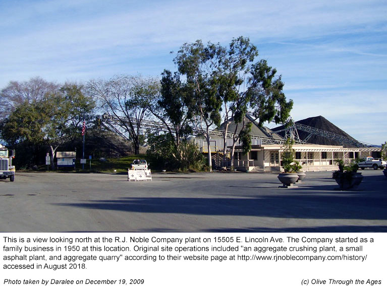
 R.J.
Noble Company:
This company operates in the construction industry in the local
area and in Corona, California. Their main plant [pictured right
in 2009] was founded at this site in 1950, on the north side of
Lincoln Ave., east of the Santa Ana River, which was then a part
of Olive. R.J.
Noble Company:
This company operates in the construction industry in the local
area and in Corona, California. Their main plant [pictured right
in 2009] was founded at this site in 1950, on the north side of
Lincoln Ave., east of the Santa Ana River, which was then a part
of Olive. |
|
 |
| |
|
|
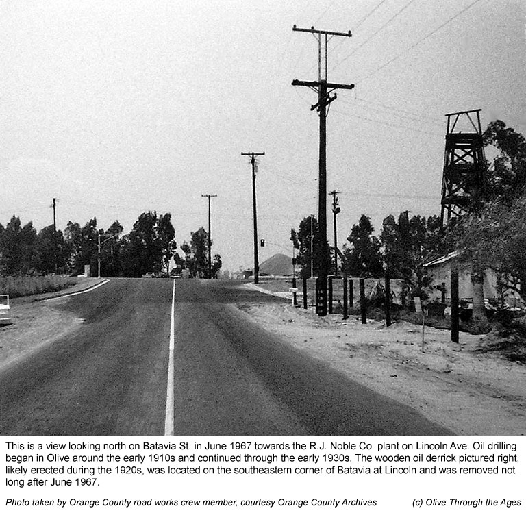
 Oil
Derrick: This wooden oil derrick [pictured
right in June 1967] stood near the southeastern corner of Batavia
St. at Lincoln Ave. from the 1910s until the late 1960s. This was
one of several oil derricks in Olive, as drilling for oil was common
in Orange County during the first quarter of the 20th Century. Oil
Derrick: This wooden oil derrick [pictured
right in June 1967] stood near the southeastern corner of Batavia
St. at Lincoln Ave. from the 1910s until the late 1960s. This was
one of several oil derricks in Olive, as drilling for oil was common
in Orange County during the first quarter of the 20th Century. |
|
 |
| |
|
|
_______________________________________________
Top of page |
Tour index | Previous
| Next
_______________________________________________
|
