| Olive
Through the Ages
Click/tap the map below to view it larger.
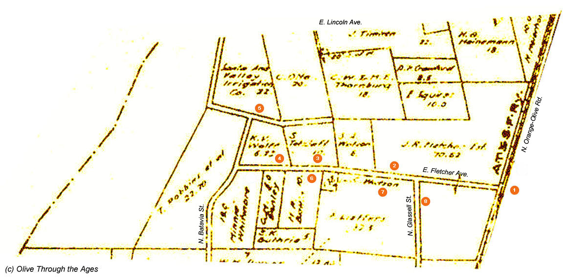
Click/tap the link (A-K) to go to that section: Main,
A,
B, C,
D, F,
G, H,
I, J,
K
_____________________________________________________________________________
|  Santa
Fe depot at St. James: A wooden depot was built in 1887 for
the up-and-coming town of St. James, located south of Olive Heights.
When St. James began to prove itself to be just another "paper
town," in August 1890, the depot was put on wheels and rolled
up the railroad tracks to the prosperous town of Olive. The depot
at Olive [pictured circa 1912 in the image at right] was rebuilt
after a fire in October 1899 nearly destroyed the original wooden
structure. Santa
Fe depot at St. James: A wooden depot was built in 1887 for
the up-and-coming town of St. James, located south of Olive Heights.
When St. James began to prove itself to be just another "paper
town," in August 1890, the depot was put on wheels and rolled
up the railroad tracks to the prosperous town of Olive. The depot
at Olive [pictured circa 1912 in the image at right] was rebuilt
after a fire in October 1899 nearly destroyed the original wooden
structure.
|
|
 |
| |
|
|
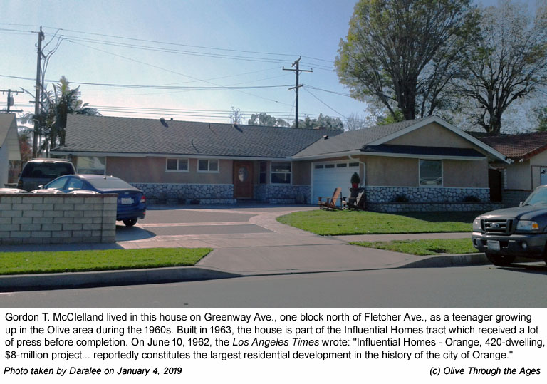
|  Gordon
McClelland family home: Author and historian Gordon T. McClelland
spent his teenage years growing up in this home [pictured right
in 2019] on Greenway Ave., one block north of Fletcher Ave. The
McClelland family moved into the newly-built, Influential Homes
tract in 1963 when the local landscape was transitioning from
citrus groves and poultry ranches to housing tracts and schools. Gordon
McClelland family home: Author and historian Gordon T. McClelland
spent his teenage years growing up in this home [pictured right
in 2019] on Greenway Ave., one block north of Fletcher Ave. The
McClelland family moved into the newly-built, Influential Homes
tract in 1963 when the local landscape was transitioning from
citrus groves and poultry ranches to housing tracts and schools.
[See Gordon's stories at Olive
memories for his descriptions of the Fletcher Ave. area from
the early 1960s to the mid-1970s.] |
|
 |
| |
|
|
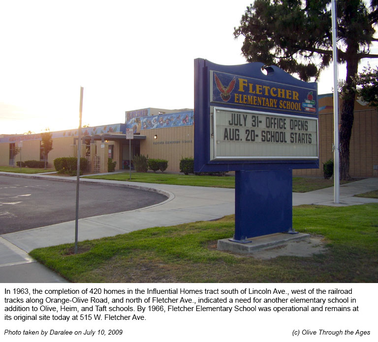
 Fletcher
Elementary School: In the early 1960s, the construction of
new housing tracts on either side of Orange-Olive Road, south
of Olive Heights, prompted the need for more public schools besides
Olive Elementary School. About that time, Taft Elementary School
and Heim Elementary School opened, followed by Fletcher Elementary
School [pictured right in 2009]. In June 1984, Olive and Heim
closed due to decreasing enrollment. The following year, St. Paul's
Lutheran School opened on the former Heim school site, while Olive
Elementary School re-opened in September 1999. Fletcher
Elementary School: In the early 1960s, the construction of
new housing tracts on either side of Orange-Olive Road, south
of Olive Heights, prompted the need for more public schools besides
Olive Elementary School. About that time, Taft Elementary School
and Heim Elementary School opened, followed by Fletcher Elementary
School [pictured right in 2009]. In June 1984, Olive and Heim
closed due to decreasing enrollment. The following year, St. Paul's
Lutheran School opened on the former Heim school site, while Olive
Elementary School re-opened in September 1999.
|
|
 |
| |
|
|
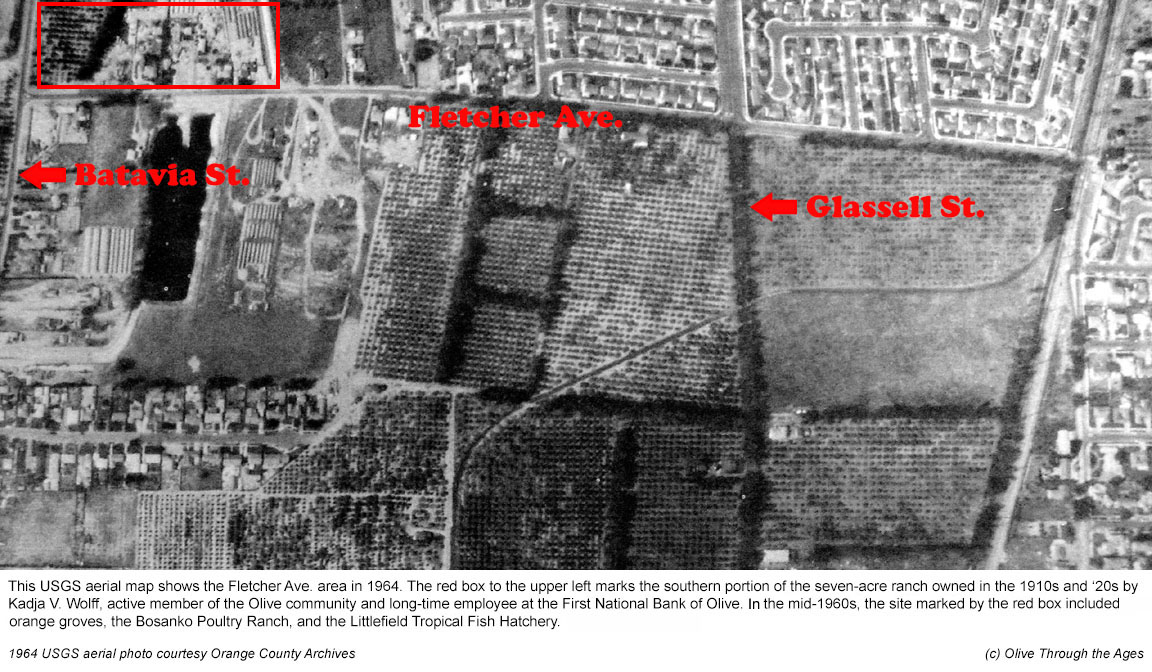
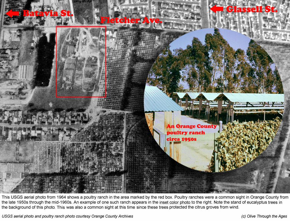
 Tropical
Fish Hatchery and Poultry Ranch Sites: During the mid-1960s,
the section of Fletcher Ave. east of Batavia St. included orange
groves, poultry ranches where chicken eggs were sold, a tropical
fish hatchery, and new and older homes dating back to the early
1920s. Tropical
Fish Hatchery and Poultry Ranch Sites: During the mid-1960s,
the section of Fletcher Ave. east of Batavia St. included orange
groves, poultry ranches where chicken eggs were sold, a tropical
fish hatchery, and new and older homes dating back to the early
1920s. |
|
 |
| |
|
|
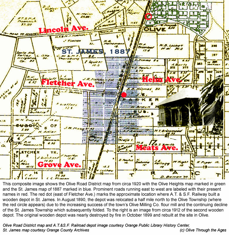
 S.A.V.I. Co. office and operations:
Local historian and author Gordon T. McClelland, who grew up in
the Fletcher Ave. area in the 1960s, recalls the Santa Ana Valley
Irrigation Company (S.A.V.I. Co.) having an office on the southeastern
corner of Fletcher Ave. at Batavia St. which he frequented, visiting
with its supervisor Sabino Ayala. The Olive Road District map from
circa 1912 [pictured in the overlay on the 1938 USGS map at right]
shows the location of S.A.V.I. Co. operations just north of the
office that later appeared on Fletcher Ave.
S.A.V.I. Co. office and operations:
Local historian and author Gordon T. McClelland, who grew up in
the Fletcher Ave. area in the 1960s, recalls the Santa Ana Valley
Irrigation Company (S.A.V.I. Co.) having an office on the southeastern
corner of Fletcher Ave. at Batavia St. which he frequented, visiting
with its supervisor Sabino Ayala. The Olive Road District map from
circa 1912 [pictured in the overlay on the 1938 USGS map at right]
shows the location of S.A.V.I. Co. operations just north of the
office that later appeared on Fletcher Ave. |
|
 |
| |
|
|
 Poultry
ranch: Mains Egg Ranch, located at
15702 E. Fletcher Ave. in 1964 [identified in the red box at right],
was one of the poultry ranches on Fletcher Ave. in the 1950s and
'60s where locals purchased fresh eggs. Poultry
ranch: Mains Egg Ranch, located at
15702 E. Fletcher Ave. in 1964 [identified in the red box at right],
was one of the poultry ranches on Fletcher Ave. in the 1950s and
'60s where locals purchased fresh eggs. |
|
 |
| |
|
|
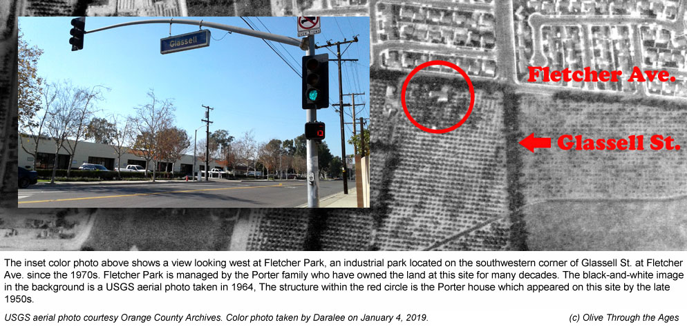
 Porter
house: The Porter family house [located in the red circle on
the 1964 USGS map at right] appears in aerial photos ranging from
the late 1950s to 1980. Instead of selling their ranch to developers,
as many other ranch-owners in the area, the family chose to retain
and develop their own property as an industrial park which they
still manage today. Porter
house: The Porter family house [located in the red circle on
the 1964 USGS map at right] appears in aerial photos ranging from
the late 1950s to 1980. Instead of selling their ranch to developers,
as many other ranch-owners in the area, the family chose to retain
and develop their own property as an industrial park which they
still manage today. |
|
 |
| |
|
|
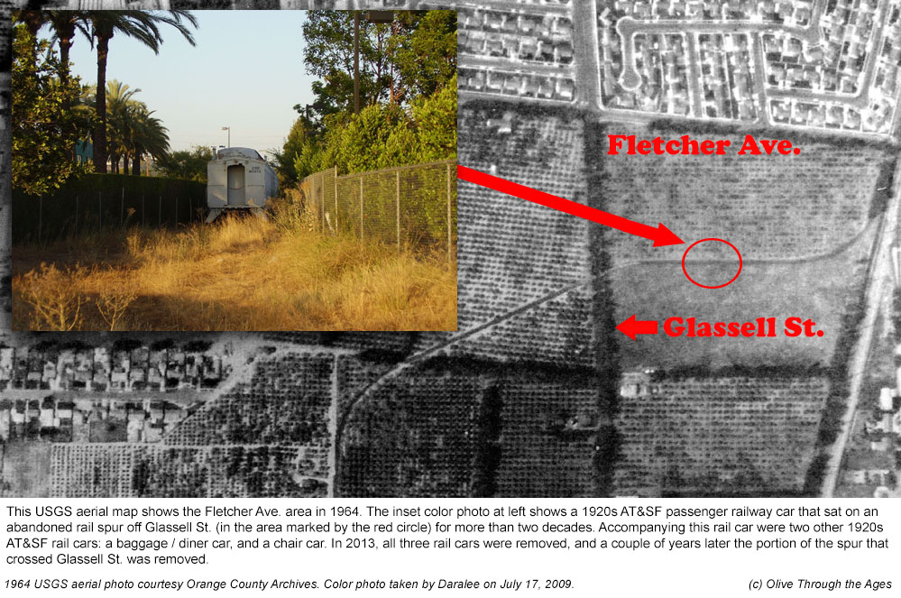
 1920s
rail car and AT&SF railway spur: For more than two decades,
three 1920's rail cars [one of which appears in the 2009 photo
at right] sat outdoors on an old, abandoned railway spur south
of Fletcher Ave. and east of Glassell St. In 2013, the rail cars
were removed. 1920s
rail car and AT&SF railway spur: For more than two decades,
three 1920's rail cars [one of which appears in the 2009 photo
at right] sat outdoors on an old, abandoned railway spur south
of Fletcher Ave. and east of Glassell St. In 2013, the rail cars
were removed.
|
|
|
| |
|
|
_______________________________________________
Top of page |
Tour index | Previous
| Next
_______________________________________________
|