|
Brief history about Olive: BC-1869 BC - 1869 | 1870
- 1899 | 1900
- 1955 | 1956
- PRESENT Before the community of Olive, California was founded, the present area it occupies was believed to have been inhabited by semi-nomadic hunters in 8000 BC. Three thousand years later in 5000 BC, seed and shellfish gatherers lived among large game hunters in this region. By 800 AD, the people of this region had developed a diversified hunting and gathering economy with extensive trade networks, social and political structures, and religious institutions. The descendants of these people are believed to have been those whom the Spaniards of the 1500s encountered and would later name the Gabrielino—derived from Mission San Gabriel—in the late 1700s.9
The Olive area was placed on the map when Gaspár de Portolá, his soldiers, and padres crossed the Santa Ana River near the present day community on July 28 and 29, 1769 en route to Monterey,6 to secure land in Northern California for Spain before the Russians could claim these territories for Russia.10 But before the Spanish could settle this land, the Gabrielino—whose region expanded north of the Olive area to the San Gabriel Valley—would need to accept their presence in this region. With the California missions project underway, Father Junipero Serra set his sights upon the Olive vicinity for his fourth mission, as it was situated on higher ground along the Santa Ana River. In his initial encounters with the nomadic Gabrielino Serra felt he was among friends, and began executing his plans in 1771, when encounters suddenly turned hostile. Mission San Gabriel Arcángel was founded many miles northwest instead—relocating in 1774 to its present site in the San Gabriel Valley. Orange County would not have a mission until November 1, 1776, when the seventh in the chain was founded at San Juan Capistrano, the County's oldest city.7
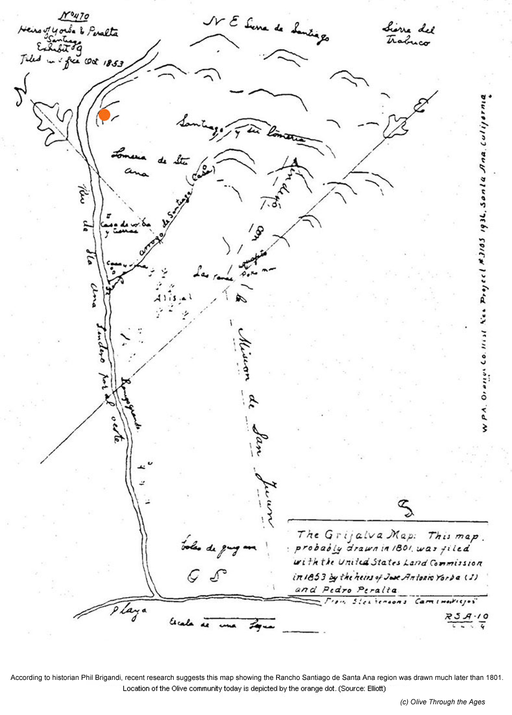
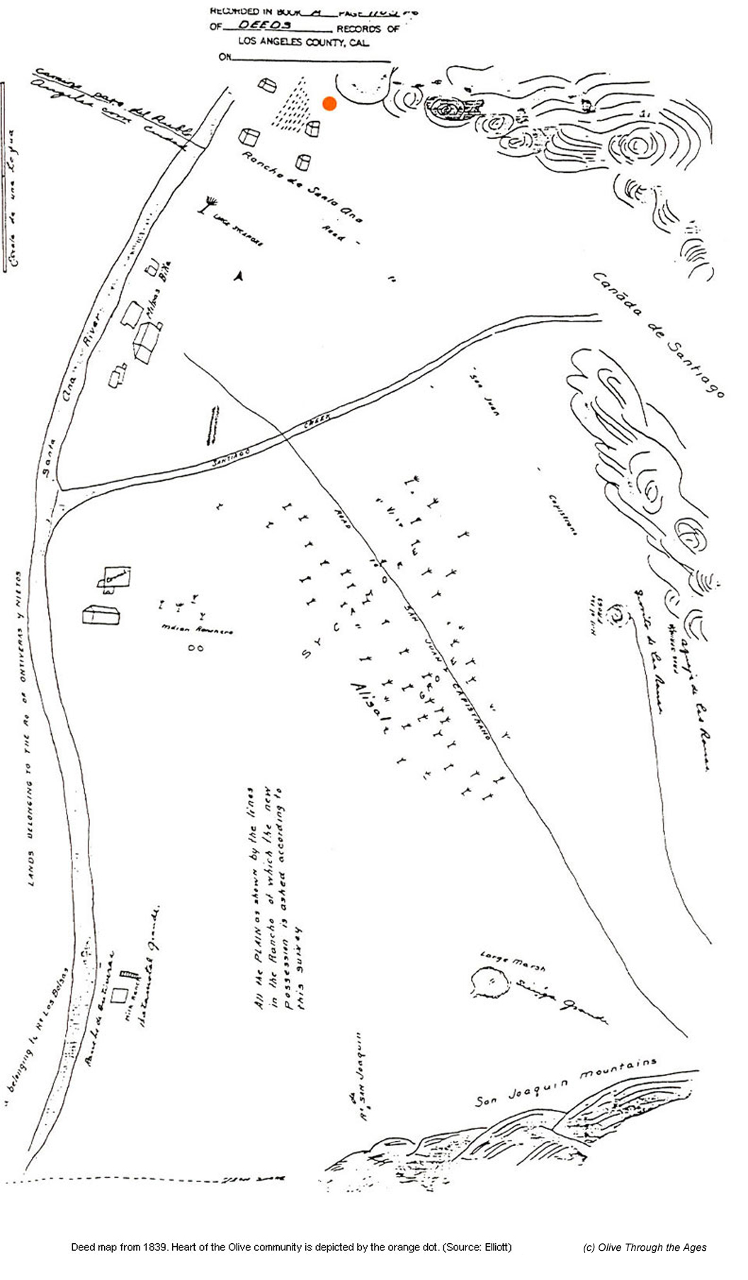
More than 25 years later, the Gabrielino no longer occupied the region, and José Antonio Yorba, a retired Spanish sergeant, came to the Olive area with his father-in-law, retired career soldier Lieutenant Juan Pablo Grijalva of Sonora, Nueva España (New Spain), a part of Mexico today. Grijalva filed a petition on December 8, 1801 with Lieutenant Manuel Rodriguez, comandante at San Diego, requesting a large tract of land that included the Olive area (see the Grijalva Map). Though he was denied a title to land, Grijalva was granted cattle grazing rights9 in the areas of Olive, Orange, Villa Park, Tustin, Santa Ana, and Costa Mesa.8 Together with Yorba, the two men and their families constructed adobe houses and established Rancho Santiago de Santa Ana. The Olive area and surrounding region soon became known as "Santa Ana of the Yorbas." Grijalva enjoyed a brief retirement at Rancho Santiago de Santa Ana before passing away in June 1806.9 Following his death, Governor José Joaquín de Arrillaga11 granted 62,512 acres of Rancho Santiago de Santa Ana on July 1, 1810 to Yorba and his nephew Juan Pablo Peralta—grandson and namesake of the late Grijalva—after Yorba's son Tomás9 obtained permission for this land from Maria Dolores Valencia, Grijalva's widow.8 This would be the only Spanish land grant in Orange County.9 Circa 1812, Yorba founded the settlement of Santa Ana Viejo (Old Santa Ana) below the bend in the Santa Ana River.2 On January 16, 1825 José Antonio Yorba passed away, survived by his second wife Maria Josefa Valencia (daughter of Juan Pablo Grijalva); their sons Tomás, José Antonio II, Bernardo, and Teodocio, and their daughters Isabél, Presentación, and Raymunda.12 He left in his will an adobe house, orchard, vineyard, cattle, oxen, sheep, and mules at Santa Ana Viejo. Tomás carried on the work left by his father and operated a store, manufactured leather goods and soap, tended herds of cattle and sheep, and farmed and irrigated the land bordering the Santa Ana River. He employed a silversmith, shoemaker, cigarmaker, and hatmaker, made flour from grain in the field, and wine and brandy from vineyard grapes.8 That same year of José Antonio Yorba's death, the Santa Ana River overflowed, flooding the Olive area. The family adobes, believed to have been situated near the "Old Santa Ana" marker, were likely affected by these rising waters. Such events were the beginning of many more changes to come in Old Santa Ana.9
The United States was rapidly expanding westward, and before the middle of the 19th century was engaged with Spain over territory disputes in California and the Southwest, resulting in the Mexican War. On January 6, 1847 Commodore Robert Stockton, General Stephen Watts Kearny, and 600 men of "the Army of the West" camped at Olive two days before their victory against General Andrés Pico and his Californios at the Battle of San Gabriel. This victory would come after their previous defeat by the Californios 85 miles south of Olive at San Pasqual on December 6, 1846.13 The Battle of San Pasqual, the bloodiest military engagement on California soil, marked the U.S.'s final defeat in the Mexican War before all of California would be acquired as a result of the Treaty of Guadalupe Hidalgo,14 signed on February 2, 1848. The Treaty also gave the U.S. the land at present-day Arizona, New Mexico, Texas, and parts of Colorado, Nevada, and Utah.15 By 1860, a year before the U.S. Civil War began, Desiderio Burruel, son-in-law of Teodocio Yorba—the youngest of José Antonio Yorba's sons—was allotted the land at Olive. The higher land became known as "Burruel Point."16 During this decade, life did not go smoothly for the Yorbas. Brief spells of heavy rainfall caused the Santa Ana River to flood the Olive area in 1861 and 1862,9 but even worse, the drought that swept over the Southland devastated crops and livestock.17 Teodocio passed away in 186312 after suffering a stroke and significant financial losses caused by the Great Drought of the 1860s.17 The Yorba descendants were now in debt, and in 1868 faced a civil suit by 100 claimants to the land at Rancho Santiago de Santa Ana, questioning the legitimacy of the original land grant. Among the claimants were pioneers James McFadden, William Spurgeon, Columbus Tustin, and Alfred Beck Chapman.17 As a result of the settlement, Rancho Santiago de Santa Ana was dissolved, and the land at Santa Ana Viejo sold. A portion of the Olive area was named the Olive Ranch, possibly for the olive trees planted in the area by the Yorbas.18 Santa Ana Viejo lost its name the following year when the present city of Santa Ana was founded by William Spurgeon—who purchased the land from Jacob Ross, Sr. (Ross had previously purchased the land at present day Santa Ana from Yorba's descendants.)8 With the loss of their land, the Yorba family's rancho life had come to an end. _____________________________________ |
||||||||||||||||||||
| Copyright © 2005 - Daralee's Web World. All rights reserved. | ||||||||||||||||||||