|
Brief history about Olive: 1870-1899 BC - 1869
| 1870 - 1899 | 1900
- 1955 | 1956
- PRESENT The 1870s brought about the beginning of progressive changes in the Olive area. In 1871 the completion of the A.B. (Alfred Beck) Chapman Canal further irrigated the land. Eight feet wide by four feet deep, the canal extended the irrigation ditch the Yorbas created to bring water from the Santa Ana Canyon region to their property at Olive. Following the natural contours of the terrain, the path of the ditch can be traced today along Canal Street which winds behind The Village at Orange mall.7 With water now available south of the hill at Olive, the surrounding area soon became settled. To accommodate the growing number of families in the area, the Olive Grammar School was formed16 on June 6, 1876. The school began operating in 1877 out of a home located a half mile south of the present Olive community. This is believed to be the site Heim Elementary School8 would occupy from 1963 (see 1966 photo)52 to June 1984, which later would be occupied by St. Paul's Lutheran School9 (see 2006 photo) when Heim Elementary closed its doors at the end of the 1984 school year due to declining enrollment.20 On August 6, 1877 the Santa Ana Valley Irrigation Company (S.A.V.I.) incorporated to provide water to farmers in the Olive area, Orange, Santa Ana, and Tustin.7 The following year, S.A.V.I. enlarged the irrigation ditch to the wooden tunnel in Olive to the dimensions of 10 feet wide at the bottom, 22 feet wide at the top, and four feet deep. The railroad, Olive flour mill, and land boom
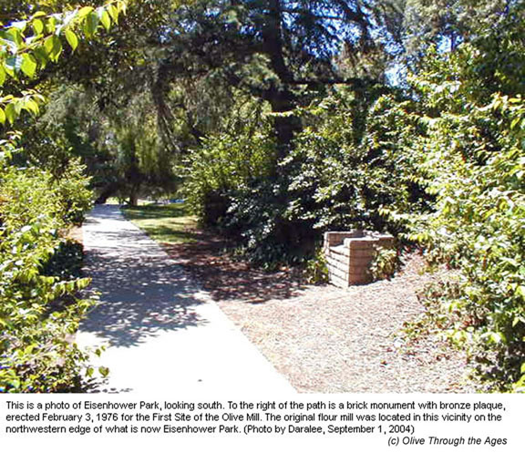
In 1881 Iowan merchant-miller Thomas Dillin and his wife and sons—Curtis, John, and William—headed West, making their new home in the Santa Ana Valley.18 On January 16, 1882 Tom and Curtis were granted a lease by the S.A.V.I. Board of Directors for water and power on five acres of land in Olive.8 They built a three-story flour mill beside the irrigation canal, at what today is the northwestern edge of Eisenhower Park in Orange (see 2004 photo of the site marker). The Dillin Mill (or Santa Ana Valley Roller Mill) began operating on November 4. The same year the Mill was built, the newly constructed railroad in Santa Ana Valley began bringing farmers to the region. Business began to thrive for the Dillin Mill. On January 31, 1883 German emigrant Louis Schorn—a miller, tradesman, and farmer, whose wife was the sister of Curtis Dillin's spouse—bought a half interest in the Mill.18 Shortly thereafter, the Mill became the principal industry in the Santa Ana Valley, with wheat brought in from Pomona, Spadra, Wilmington, and San Fernando.8
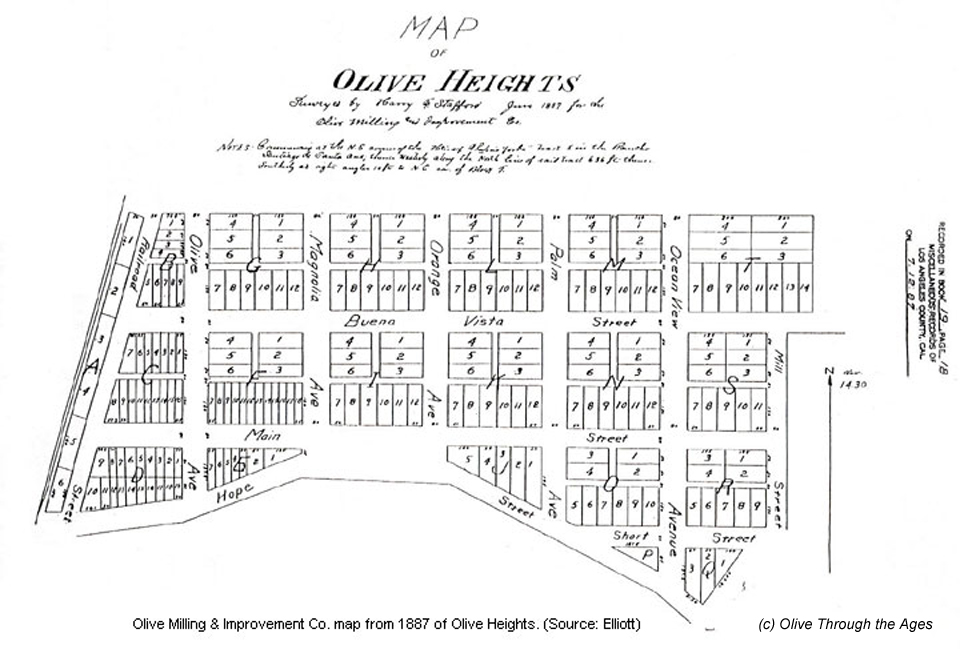
By 1887 Olive had become an established community. The Atchison, Topeka and Santa Fe (A.T. & S.F.) Railroad had rails running north to south through the region, and the "Land Boom of the '80s" was at its peak, bringing more and more tourists and homeseekers7 to buy property, work, and live in Southern California. Olive's first post office opened on February 2,37 and in May Tom Dillin formed the Olive Milling, Land & Improvement Company. The Company purchased and subdivided land west of the mill, creating the Olive Heights tract (see 1887 map). The original tract included the following street and avenues running north and south: Railroad Street (now called Orange-Olive Road), Olive Avenue, Magnolia Avenue, Orange Avenue, Palm Avenue, Ocean View Avenue, and Mill Street (which no longer exists); and the following streets running east and west: Buena Vista Street, Main Street, Hope Street (now called Lincoln Avenue), and Short Street (which exists in part). After the land was subdivided, Louis Schorn built a Victorian style home that still stands today on the western corner of Bixby at 8571 Ocean View (see 2004 photo), and pepper trees were planted on the Heights. Many of these trees still exist today. As work at the mill began to increase, Schorn opened the Olive Heights Hotel on Main Street (see early 1900s photo) to accommodate workers. Along with a general store, Olive also had its first saloon (Antune's) located on the southeastern corner of Hope (Lincoln) and Railroad (Orange-Olive).
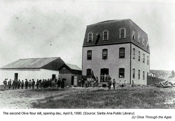
The great Southern California land boom ended as quickly as it began. In 1888, Tom Dillin retired from his position at the Olive Milling, Land & Improvement Company and all members of the Dillin family moved to Los Angeles, except Curtis and his family who remained at the Olive flour mill. Sadly for the family, Tom Dillin passed away the following year on September 16, 1889. The Olive Milling, Land & Improvement Company was now under the presidency of Louis Schorn, who faced adversity when fire burned the Mill on the 29th that month. Schorn had the Mill rebuilt at a new site with access to the railroad, and business resumed on April 8, 1890 (see 1890 photo). The location of the second mill is identified today at the southwestern edge of Eisenhower Park, approximately where the Lakeside Professional Building stands (see 2005 photo). That autumn, the Olive flour mill was advertised as the most important manufacturer in Orange County, based on its continued financial success. The Mill was so prosperous that A.T. & S.F. moved its depot to Olive from the up and coming community of Saint James, located a half mile south of Olive. The wooden depot was positioned to the east of the tracks on Railroad Street, just north of Hope Street (see 1912 photo, showing the depot to the left). At the request of the Olive Milling Company, A.T. & S.F. ran a spur track along Hope Street to the mill. On April 14, 1892 the completion of the concrete S.A.V.I. canal/tunnel further helped the Mill's productivity, as the largest concrete pipe carrying water from the Santa Ana River meant the end of continual breaks in the original wooden tunnel. Meanwhile, the ongoing threat of the development of the Saint James community prompted the Olive Milling, Land & Improvement Company to move the Olive Grammar School to Olive Point.18 In 1895 the Olive Grammar School was constructed as a white, two-story building on the hill at Olive (see 1915 photo showing the school house in the background).16 The community of Saint James never developed into a town, however, and in the 1960s was designated in part by a street named St. James Avenue—located one block north of Heim Avenue today (see 2005 photo).18 _______________________________________________ |
||||||||||||||||
| Copyright © 2005 - Daralee's Web World. All rights reserved. | ||||||||||||||||