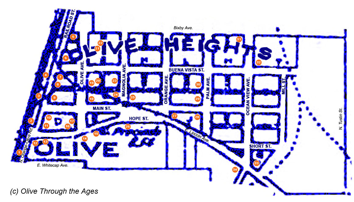
Click/tap the map below to view it larger.
Click/tap the link (A-K) to go to that section: Main,
A,
B, D,
E, F,
G, H,
I, J,
K
_____________________________________________________________________________
Click/tap a Site Number ("1" - "34")
below for information about that site. Click/tap any image on this page
to view a larger image in a separate window/tab.
| Site
Number: 1 |
2 |
3 |
4 |
5 |
6 |
7 |
8 |
9 |
10 |
11 |
12 |
13 |
14 |
15 |
16 |
17 |
18 |
19 |
20 |
21 |
22 |
23 |
24 |
25 |
26 |
27 |
28 |
29 |
30 |
31 |
32 |
33 |
34 |
| |
|
|
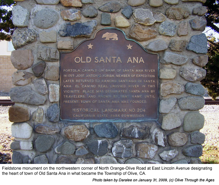
|  Old
Santa Ana marker: In 1957, California State Historical Marker
No. 204 [pictured right] was erected on the northwestern corner
of North Orange-Olive Road at East Lincoln Avenue. The marker
designates this site as being the heart of "Old Santa Ana"
which later became known as Olive. Old
Santa Ana marker: In 1957, California State Historical Marker
No. 204 [pictured right] was erected on the northwestern corner
of North Orange-Olive Road at East Lincoln Avenue. The marker
designates this site as being the heart of "Old Santa Ana"
which later became known as Olive.
[See images
of the low, brick and mortar border that surrounded the base
of the monument from the 1960s, and the removal of this border.
See June
25, 2019 image for a view without the brick border.] |
|
 |
| |
|
|
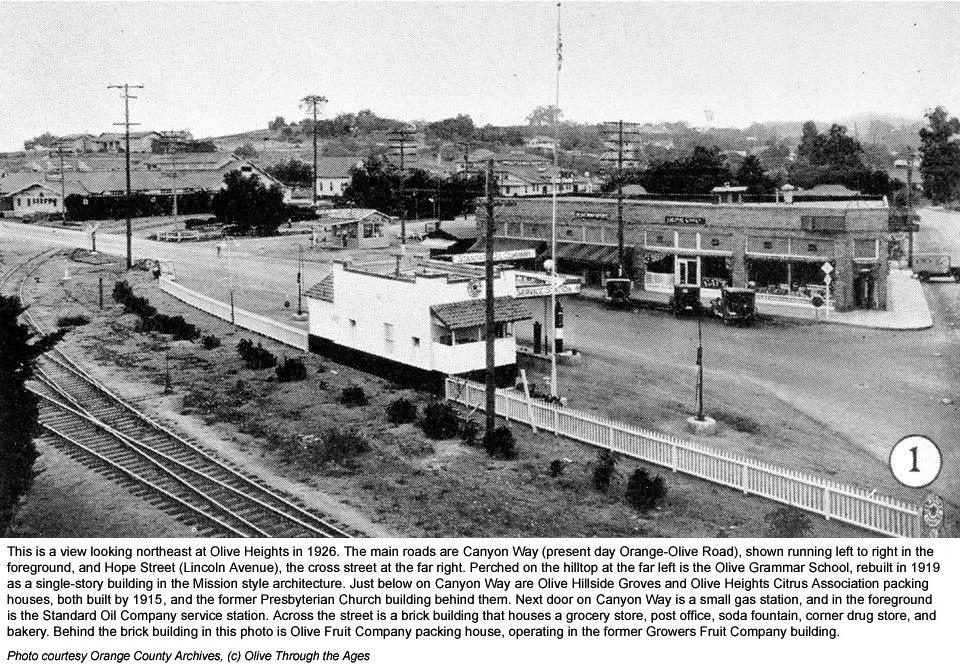
|  Standard
Oil Company service station: In 1926, this service station
[pictured right] stood at the northeastern corner of Railroad
Street (2 Canyon Way in the 1930s) and Anaheim-Olive Boulevard
(Lincoln). Standard
Oil Company service station: In 1926, this service station
[pictured right] stood at the northeastern corner of Railroad
Street (2 Canyon Way in the 1930s) and Anaheim-Olive Boulevard
(Lincoln).
A photo from circa
1918 shows this same structure, though the name of the service
station is not unidentified. This structure does not appear in
the 1938 USGS aerial photo. |
|
 |
| |
|
|
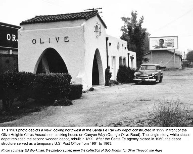
|  Olive
Station Santa Fe railway depot: The wooden Santa Fe depot
[pictured top right in 1912] built in 1887, was relocated from
the nearby community of St. James on the western side of Railroad
Street (Orange-Olive Road) in 1890. Santa Fe rebuilt the wooden
depot after a fire in late October 1899 nearly destroyed it. In
1929, Santa Fe rebuilt the depot of stucco [pictured bottom right
in the 1961], at the address listed as 102 Railroad Street (also
known as Canyon Way at that time). Olive
Station Santa Fe railway depot: The wooden Santa Fe depot
[pictured top right in 1912] built in 1887, was relocated from
the nearby community of St. James on the western side of Railroad
Street (Orange-Olive Road) in 1890. Santa Fe rebuilt the wooden
depot after a fire in late October 1899 nearly destroyed it. In
1929, Santa Fe rebuilt the depot of stucco [pictured bottom right
in the 1961], at the address listed as 102 Railroad Street (also
known as Canyon Way at that time).
Olive Station U.S. Post Office: The Santa
Fe agency closed in 1960, and following the loss of the Olive
community's post office to fire in 1961, the depot was used as
a temporary post office. On October 5, 1964, the depot structure
was razed due to the realignment of Orange-Olive Road, and the
Olive Station post office relocated to its present site in the
Orange-Olive Center strip mall at 2683 N. Orange-Olive Road. |
|
|
| |
|
|
 OHCA
warehouse/fertilizer shed: Circa 1900, Olive Heights Citrus
Association packing house built a warehouse beside the railroad
tracks which was later used as a fertilizer shed. [Pictured right:
the storage / fertilizer shed in 1969.] This shed was relocated
and is situated today on residential property, behind a block wall
on the opposite side of the railroad tracks. [See
2009 image.] OHCA
warehouse/fertilizer shed: Circa 1900, Olive Heights Citrus
Association packing house built a warehouse beside the railroad
tracks which was later used as a fertilizer shed. [Pictured right:
the storage / fertilizer shed in 1969.] This shed was relocated
and is situated today on residential property, behind a block wall
on the opposite side of the railroad tracks. [See
2009 image.] |
|
 |
| |
|
|
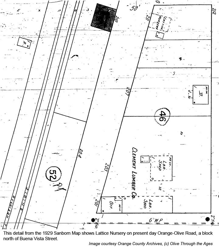
 Olive
Heights Nursery: In 1907 this business was listed in the Orange
Directory at 4 mi N., Olive. The 1929
Sanborn Map shows a nursery being located north of Clement Lumber
[detail from this map pictured right]. Olive
Heights Nursery: In 1907 this business was listed in the Orange
Directory at 4 mi N., Olive. The 1929
Sanborn Map shows a nursery being located north of Clement Lumber
[detail from this map pictured right]. |
|
 |
| |
|
|
 Clement
Lumber Company: In 1922 this business [pictured top right]
was located at 203 Railroad Street (known as Canyon Way in the
late 1920s and Orange-Olive Road today). The business was last
at this location circa 1940. [See 1929
Sanborn Map detail.] Clement
Lumber Company: In 1922 this business [pictured top right]
was located at 203 Railroad Street (known as Canyon Way in the
late 1920s and Orange-Olive Road today). The business was last
at this location circa 1940. [See 1929
Sanborn Map detail.]
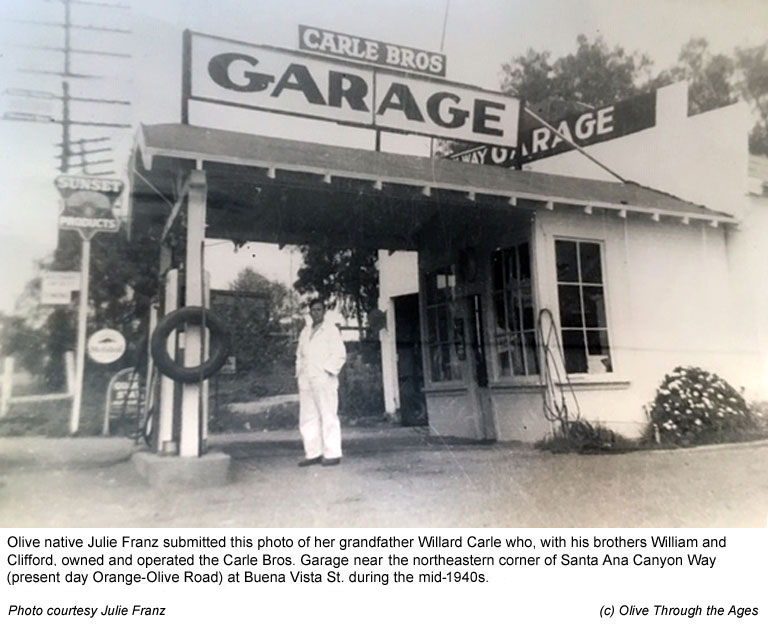
Carle Bros. Garage: Willard, William, and Clifford Carle's
automotive garage [pictured middle right circa 1946], was located
north of the Olive Motel on Santa Ana Canyon Road. [See mid-1940s
picture of William, Clifford, and Willard Carle at the Garage.]
This garage, under different ownership in the 1950s and 1960s,
was listed as Custom Body Shop in the 1958 local directory, at
8610 Santa Ana Canyon Road.
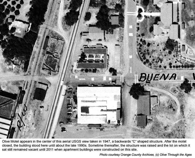
Olive Motel (and Apartments): The motel apartment building
was first listed in the directory in 1940, and in 1947 [pictured
bottom right] was listed at 8582 Santa Ana Canyon. By 1961, the
address for this location had changed to 8620 Santa Ana Canyon
Road.
The lot on which the motel apartments once stood was vacant in
the early 2000s through 2010 [see image
from 2010]. Today Buena Vista apartments stand at this corner.
[See
2011 image showing apartments under construction.] |
|
|
| |
|
|
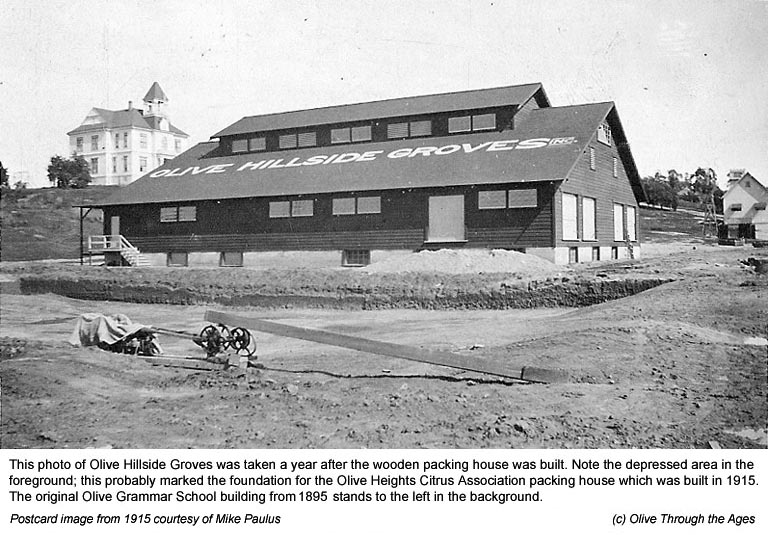
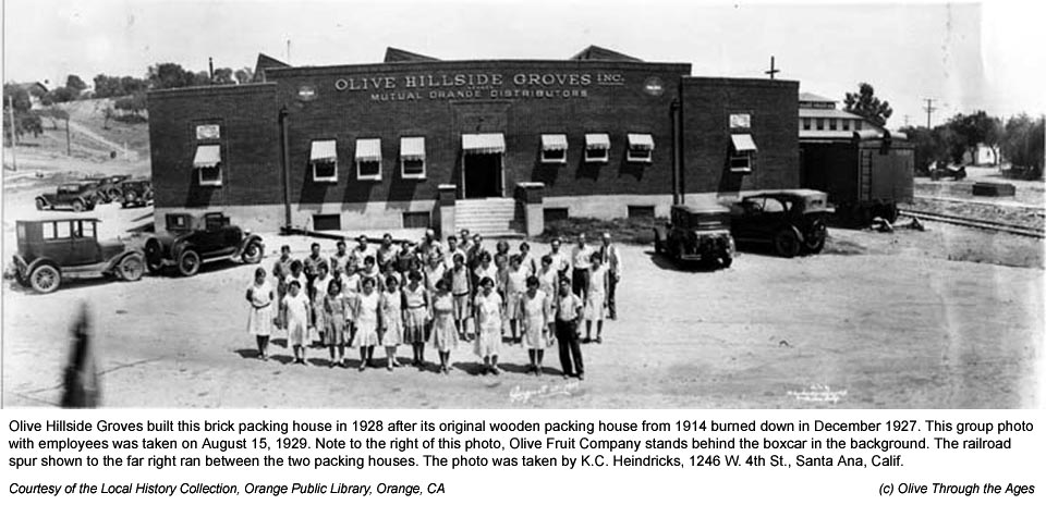
 Olive
Hillside Groves, Incorporated: This packing house was built
in 1914 [pictured 1915 top right] and burned down on December
16, 1927, along with neighboring Olive Heights Citrus Association.
In 1928 the packing house was rebuilt of brick on the same site
[pictured 1929 bottom right], at 109 Railroad Street (listed as
8642 Santa Ana Canyon Road in 1947). Operations at this Mutual
Orange Distributors house ceased in 1960. Olive
Hillside Groves, Incorporated: This packing house was built
in 1914 [pictured 1915 top right] and burned down on December
16, 1927, along with neighboring Olive Heights Citrus Association.
In 1928 the packing house was rebuilt of brick on the same site
[pictured 1929 bottom right], at 109 Railroad Street (listed as
8642 Santa Ana Canyon Road in 1947). Operations at this Mutual
Orange Distributors house ceased in 1960.
Merlex Stucco: In 1963, Merlex Stucco began operating
in this building—listed at 8642 N. Orange-Olive Road in
1965—and remained in business here at 2911 N. Orange-Olive
Road until it was acquired by Parex USA in 2016. [See 1969
image and
2009 image.] Parex moved out in 2020.
|
|
|
| |
|
|
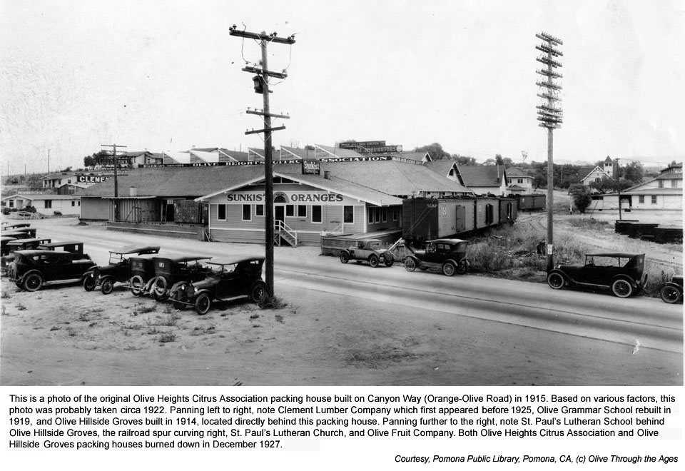
 Olive
Heights Citrus Association: Incorporated as a Sunkist packing
house in 1914, its facility was built on the eastern side of Railroad
Street at 2 north Hope (Orange-Olive Road) in 1915 [pictured right
circa 1922]. A fire on December 16, 1927 burned down this packing
house and the neighboring Olive Hillside Groves packing house. Olive
Heights Citrus Association: Incorporated as a Sunkist packing
house in 1914, its facility was built on the eastern side of Railroad
Street at 2 north Hope (Orange-Olive Road) in 1915 [pictured right
circa 1922]. A fire on December 16, 1927 burned down this packing
house and the neighboring Olive Hillside Groves packing house.
In 1928, Olive Heights Citrus Association rebuilt its packing
house of concrete on the western side of the railroad tracks at
104 Railroad Street. [See 1929
Sanborn Map.] |
|
|
| |
|
|
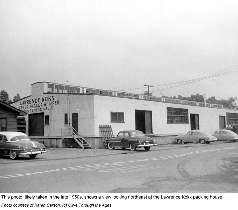
 Lawrence
Kokx packing house: In 1945 Lawrence Kokx built a vegetable
and fruit packing house at 8672 Santa Ana Canyon Road, on the
south side of Olive Hillside Groves [pictured right in the 1950s].
This packing house closed in 1958. Lawrence
Kokx packing house: In 1945 Lawrence Kokx built a vegetable
and fruit packing house at 8672 Santa Ana Canyon Road, on the
south side of Olive Hillside Groves [pictured right in the 1950s].
This packing house closed in 1958.
In 2001, Vero, a division of Merlex Stucco, began operating out
of the former Lawrence Kokx packing house and continued doing
business at that location until the company's acquisition by Parex
USA in 2016. [See 2009
image.]
As of the summer of 2016, the large "Central Valley Builders
Supply" banner appears across the top of this building. |
|
|
| |
|
|
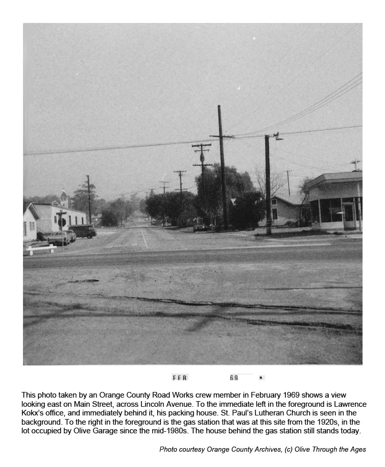
 Gas Station: Stood on the southeastern corner at Main and
13 Canyon Way (Orange-Olive Road) from at least 1926 to 1969.
Whether the gas station was in operation during all of the years
has not yet been determined. [See 1929
Sanborn Map and
detail from that map. Pictured right: the gas station in 1969.]
Gas Station: Stood on the southeastern corner at Main and
13 Canyon Way (Orange-Olive Road) from at least 1926 to 1969.
Whether the gas station was in operation during all of the years
has not yet been determined. [See 1929
Sanborn Map and
detail from that map. Pictured right: the gas station in 1969.]
Dodge Glenn Union Service Station: This business was in
operation at 8692 Santa Ana Canyon Road in 1961.
Olive Garage: Moved to this site from 606 E. Lincoln Avenue
in 1984. Still located here today at 2845 N. Orange-Olive Road.
[See 2010
image.] |
|
 |
| |
|
|
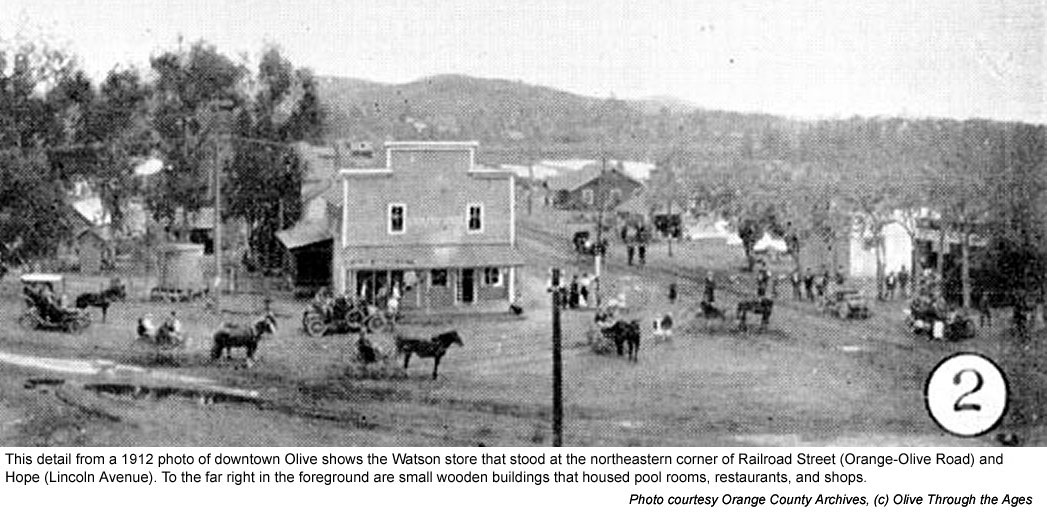
|  Watson Business Site: From at least 1899 until early 1923,
a wooden store [pictured top right in 1899] stood on the northeastern
corner of Hope (Lincoln) and Orange-Olive Road. [See 1912
image and 1915
image—in the latter image the store is located in the
background behind the bank.]
Watson Business Site: From at least 1899 until early 1923,
a wooden store [pictured top right in 1899] stood on the northeastern
corner of Hope (Lincoln) and Orange-Olive Road. [See 1912
image and 1915
image—in the latter image the store is located in the
background behind the bank.]
Edwards, Bortz, and Fletcher Business Block:
In June 1923 [see 1926 image], a brick building
[pictured bottom right in 1951] was completed at this corner,
replacing the wooden store. This building contained the Olive
Bakery (at 7 Hope in 1926), Olive Cafe (at 3 Canyon Way in 1926),
Olive General Store (at 5 Canyon Way in 1928), Olive Post Office
(at 7 Canyon Way in 1929), and Olive Pharmacy and drugstore (at
1 Canyon Way in 1926). In 1937, this building housed the Olive
Food Market (listed at 8702 Santa Ana Canyon Road in 1950), Olive
Cafe, U.S. Post Office, and Olive Pharmacy (listed at 8722 Santa
Ana Canyon Road in 1950). The building burned
down in 1961 and would not be rebuilt. |
|
 |
| |
|
|
|  Antune's
Saloon: In 1887, Miguel Antunez began operating this saloon
at the southeast corner of Hope (Lincoln) and Railroad Street
(Orange-Olive). The saloon closed in 1891. [Top right: see buildings
at far right in this detail from a 1912 photo.] Antune's
Saloon: In 1887, Miguel Antunez began operating this saloon
at the southeast corner of Hope (Lincoln) and Railroad Street
(Orange-Olive). The saloon closed in 1891. [Top right: see buildings
at far right in this detail from a 1912 photo.]
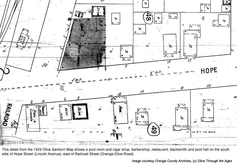
Olive Billiard Parlor, Cigar Shop: The billiard
parlor and cigar shop stood at the southeast corner of Railroad
Street at 2 Hope Street in 1922. The Olive Pool Hall remained
on the corner until circa 1958, at the address listed as 16432
Santiago (Lincoln).
Olive Barber Shop: Stood next door to the
pool parlor at 4 Hope Street in 1922 until circa 1950, when the
address was listed as 16432 Santiago. [See buildings on the south
side of Hope (Lincoln) in this detail from the 1929 Sanborn Map.]
|
|
|
| |
|
|
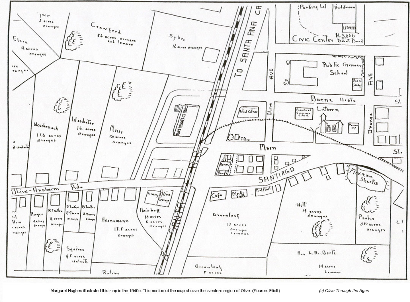
 Restaurant:
Stood next door to the Olive Barber Shop at 6 Hope in 1929. This
restaurant was included on Margaret Hughes' map in 1946. [See
1929
Sanborn Map detail, and 1940s map by Margaret Hughes, top
right.] Restaurant:
Stood next door to the Olive Barber Shop at 6 Hope in 1929. This
restaurant was included on Margaret Hughes' map in 1946. [See
1929
Sanborn Map detail, and 1940s map by Margaret Hughes, top
right.]
Olive Blacksmith Shop: Stood on southside Hope 3 east
circa 1919; listed as 8 Hope in 1929, next door to the restaurant.
[See 1929
Sanborn Map detail, and 1940s map by Margaret Hughes.]
Olive Forgeing and Welding: This shop stood on the corner
of Santiago (Lincoln) at Orange-Olive Road in 1958 and 1959, most
likely occupying the same building as the former Olive Blacksmith
Shop. [See 1959
USGS aerial map detail.]
Signal Oil Company Service Station: This service station
stood on the realigned southeastern corner of Lincoln at 2101
N. Orange-Olive Road circa 1964 to 1966. [See 1964
USGS detail photo.]
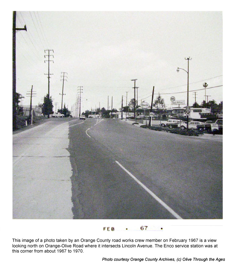
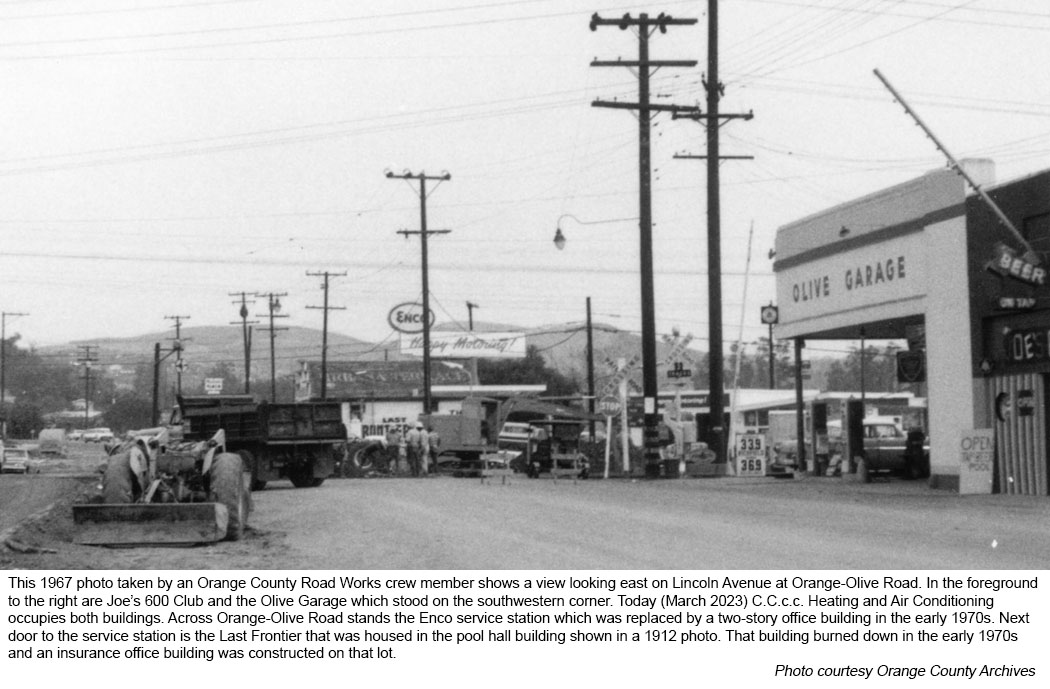
Enco Products Service Station: This service station stood
here at 2101 N. Orange-Olive Road circa 1967 to 1970. [See February
1967 image at middle right, and another 1967
image.]
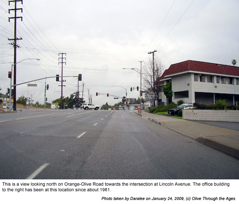
Wooden, two-story office building: This structure was
built about 1981 and still stands today on the southeastern corner
of Orange-Olive at 710-722 E. Lincoln Avenue. [See 2005
image, and 2009 image at right.]
Pool room: Located east of the blacksmith shop at 12 Hope
Street, this pool room appears in the 1912 photo mentioned above
and was included on Margaret Hughes' map in 1946. [See 1929
Sanborn Map detail and 1940s map by Margaret Hughes.] The
building, which housed the Last Frontier bar in the 1960s, burned
down in the early 1970s. [See image at right from 1967.]
|
|
|
| |
|
|
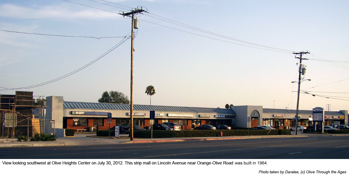
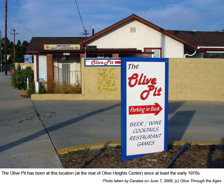
|  Olive
Heights Center: This strip mall [pictured top right in 2012]
was built in 1964 and still occupies the south side of Lincoln
Avenue mid-way between Orange-Olive Road and Magnolia Avenue.
When first constructed, tenants included Olive Cleaners at 826
E. Lincoln (located today at 820 E. Lincoln), and Olive Medical
at 830 E. Lincoln. Olive Heights Pharmacy was listed at 820 E.
Lincoln Avenue in the 1968 directory, Olive-Heights Market was
listed at 824 E. Lincoln in 1971 (the same address as Hi-Ho Market
and Liquor today), and The Olive Pit was listed at 834 E. Lincoln
in 1973—and still remains at this address today [pictured
bottom right]. Olive
Heights Center: This strip mall [pictured top right in 2012]
was built in 1964 and still occupies the south side of Lincoln
Avenue mid-way between Orange-Olive Road and Magnolia Avenue.
When first constructed, tenants included Olive Cleaners at 826
E. Lincoln (located today at 820 E. Lincoln), and Olive Medical
at 830 E. Lincoln. Olive Heights Pharmacy was listed at 820 E.
Lincoln Avenue in the 1968 directory, Olive-Heights Market was
listed at 824 E. Lincoln in 1971 (the same address as Hi-Ho Market
and Liquor today), and The Olive Pit was listed at 834 E. Lincoln
in 1973—and still remains at this address today [pictured
bottom right].
|
|
 |
| |
|
|
|  Post
Office: In 1919, the U.S. Post Office was located on the south
side of Hope Street at 4 east Olive Boulevard [mid-way between
Railroad Street and Olive Avenue in the 1929 Sanborn Map pictured
right]. The post office relocated in the 1920s to the brick building
at the northeastern corner of Railroad Street (later called Canyon
Way, and Orange-Olive Road today) and Hope Street (later called
Santiago, and Lincoln Avenue today). Post
Office: In 1919, the U.S. Post Office was located on the south
side of Hope Street at 4 east Olive Boulevard [mid-way between
Railroad Street and Olive Avenue in the 1929 Sanborn Map pictured
right]. The post office relocated in the 1920s to the brick building
at the northeastern corner of Railroad Street (later called Canyon
Way, and Orange-Olive Road today) and Hope Street (later called
Santiago, and Lincoln Avenue today).
|
|
|
| |
|
|
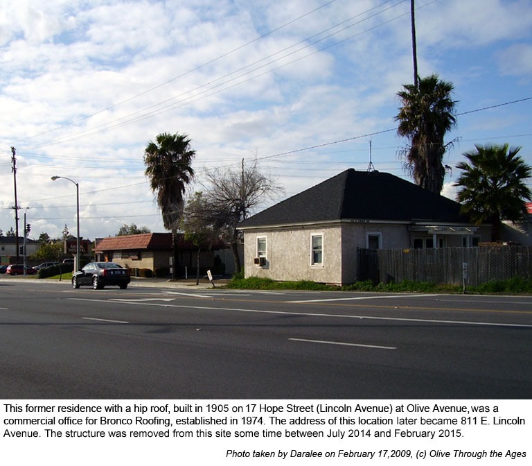
|  House
built in 1905: This former residence with a hip roof, located
on Hope Street (Lincoln Avenue) at Olive Avenue [pictured right
in 2009], became a commercial office for Bronco Roofing Company
circa 1982. [See 1929
Sanborn Map detail, 1959
USGS aerial photo detail, and 1964
USGS detail photo.] The structure was removed some time between
July 2014 and February 2015. House
built in 1905: This former residence with a hip roof, located
on Hope Street (Lincoln Avenue) at Olive Avenue [pictured right
in 2009], became a commercial office for Bronco Roofing Company
circa 1982. [See 1929
Sanborn Map detail, 1959
USGS aerial photo detail, and 1964
USGS detail photo.] The structure was removed some time between
July 2014 and February 2015.
|
|
 |
| |
|
|
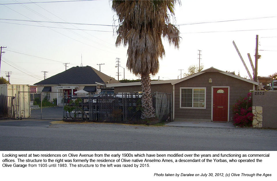
|  Anselmo
Ames house: This former residence on Olive Avenue [pictured
right in 2012] in which the Yorba family descendant lived for
many years, was modified to function as a commercial office during
the latter portion of the last century. [See 1929
Sanborn Map detail, 1959
USGS aerial photo detail, and 1964
USGS detail photo.] Anselmo
Ames house: This former residence on Olive Avenue [pictured
right in 2012] in which the Yorba family descendant lived for
many years, was modified to function as a commercial office during
the latter portion of the last century. [See 1929
Sanborn Map detail, 1959
USGS aerial photo detail, and 1964
USGS detail photo.]
|
|
 |
| |
|
|
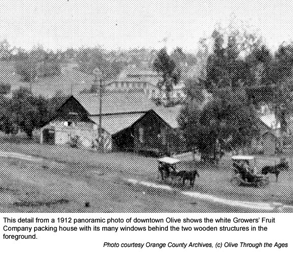
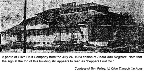
|  Growers
Fruit Company: This packing house was built at the southeastern
corner of Olive Avenue and Main Street in 1911. In 1921 Thomas
H. Peppers and his partner A.J. Miller bought out this packing
house and renamed their firm Peppers Fruit Company. In 1923 the
name of the firm changed to Olive Fruit Company [see image at
bottom right]. In 1932 a fire burned down this building at 101
Main, which would never be rebuilt. Growers
Fruit Company: This packing house was built at the southeastern
corner of Olive Avenue and Main Street in 1911. In 1921 Thomas
H. Peppers and his partner A.J. Miller bought out this packing
house and renamed their firm Peppers Fruit Company. In 1923 the
name of the firm changed to Olive Fruit Company [see image at
bottom right]. In 1932 a fire burned down this building at 101
Main, which would never be rebuilt.
|
|
 |
| |
|
|
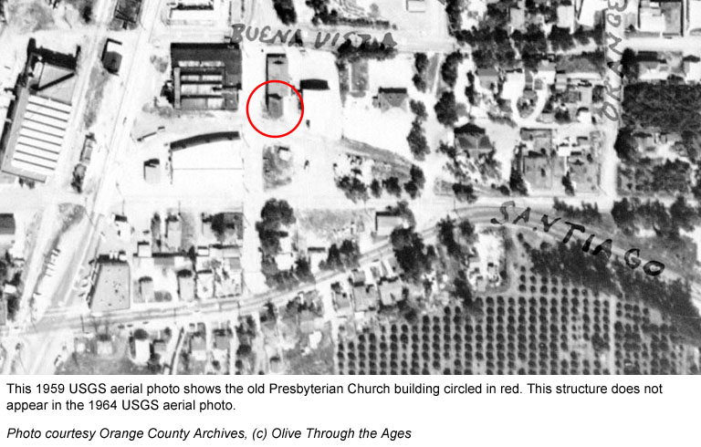
|  Storage
unit (former Presbyterian Church building): Not long after
St. Paul's Lutheran Church organization purchased the Presbyterian
Church for their first sanctuary in 1907, they began constructing
a new sanctuary that would be completed in 1913; the modified
structure used by North Orange Christian Church today. The original
Presbyterian Church sanctuary built in 1898 was relocated to the
northwestern corner of St. Paul's property [see 1959 aerial photo
at right] some time between 1913 and circa 1922. This structure,
which was labeled a storage unit in the
1926 Sanborn Map, does not appear in the 1964 USGS aerial
photo. Storage
unit (former Presbyterian Church building): Not long after
St. Paul's Lutheran Church organization purchased the Presbyterian
Church for their first sanctuary in 1907, they began constructing
a new sanctuary that would be completed in 1913; the modified
structure used by North Orange Christian Church today. The original
Presbyterian Church sanctuary built in 1898 was relocated to the
northwestern corner of St. Paul's property [see 1959 aerial photo
at right] some time between 1913 and circa 1922. This structure,
which was labeled a storage unit in the
1926 Sanborn Map, does not appear in the 1964 USGS aerial
photo.
|
|
 |
| |
|
|
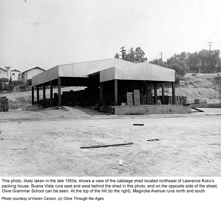
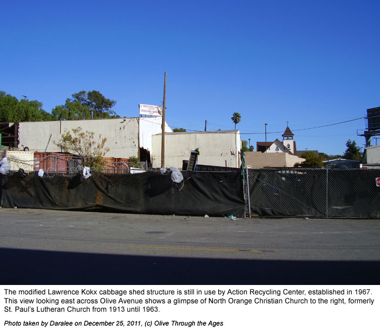
|  Lawrence
Kokx cabbage shed: This structure was built in the 1950s and
was used by Lawrence Kokx packing house as a cabbage shed [see
1950s image at top right] until the packing house closed in 1958. Lawrence
Kokx cabbage shed: This structure was built in the 1950s and
was used by Lawrence Kokx packing house as a cabbage shed [see
1950s image at top right] until the packing house closed in 1958.
Action Recycling Center: By 1967, Action Recycling Center
[see 2011 image at bottom right] was established and began operating
out of the modified cabbage shed. This recycling center still
operates in this structure as of 2023.
|
|
|
| |
|
|
|  Yorba
family's second adobe: Built on the hill at Olive after the
flood of 1825, approximately in the location where the school
houses would later be built. The home ceased to exist prior to
the 1880s. [See Grijalva
Map.] Yorba
family's second adobe: Built on the hill at Olive after the
flood of 1825, approximately in the location where the school
houses would later be built. The home ceased to exist prior to
the 1880s. [See Grijalva
Map.]
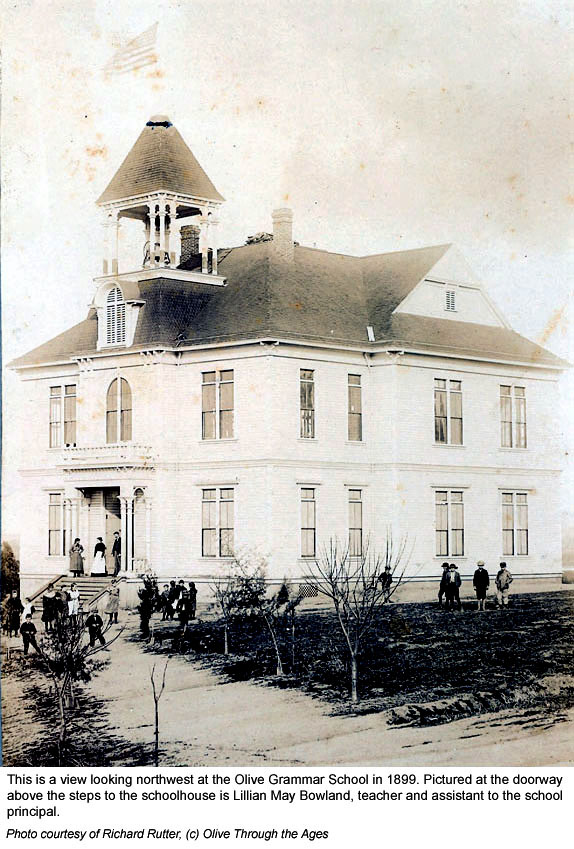
Olive Grammar School: Built here on the hill as a white,
two-story, wooden structure in 1895 [see 1899 image at right],
at the address listed as 209 Olive Avenue circa 1928, and 3038
N. Magnolia Avenue today.
The school was first rebuilt in 1919 in the Mission style of
architecture [see
1959 image], and renamed Olive Elementary School in 1953.
The school was rebuilt in 1962 to comply with building standards.
Due to declining enrollment, the school closed June 1984, and
re-opened September 7, 1999 when enrollment picked up. [See
2009 image.] |
|
 |
| |
|
|
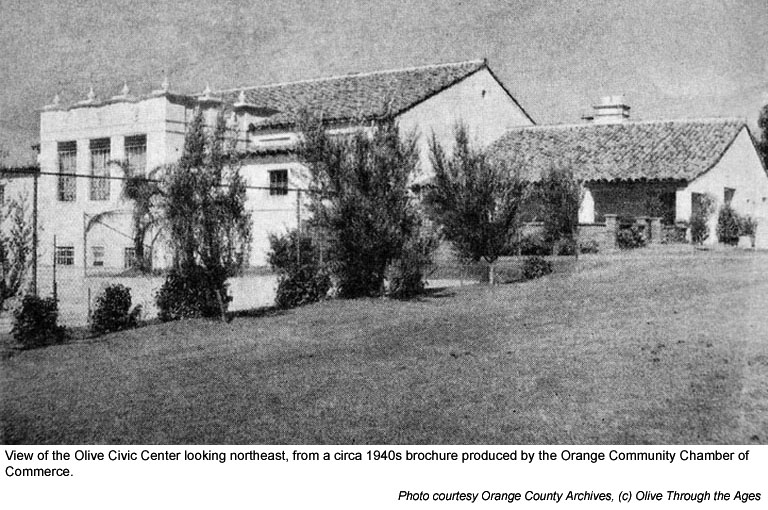
|  Olive
Civic Center: Built in the Spanish-Colonial style to the rear
of the school in 1939. Known as the Olive Community Center and
Assembly Hall, and the Olive Grammar School's Gymnasium and Auditorium.
Located at 3030 N. Magnolia Avenue, this structure is still in
use today. [See 1940s image at right, and
2009 image.] Olive
Civic Center: Built in the Spanish-Colonial style to the rear
of the school in 1939. Known as the Olive Community Center and
Assembly Hall, and the Olive Grammar School's Gymnasium and Auditorium.
Located at 3030 N. Magnolia Avenue, this structure is still in
use today. [See 1940s image at right, and
2009 image.]
|
|
 |
| |
|
|
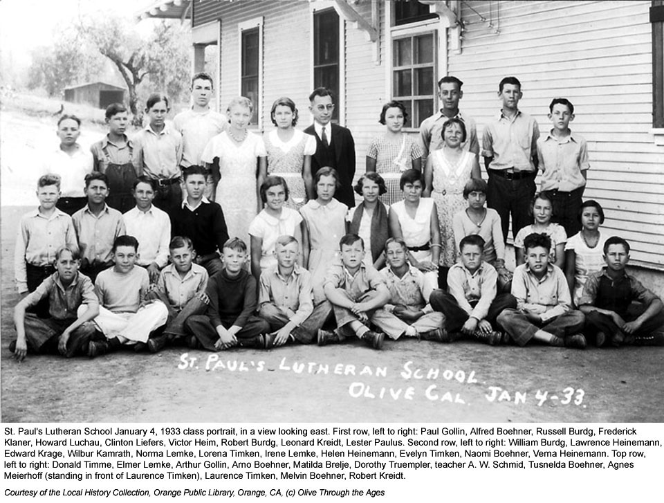
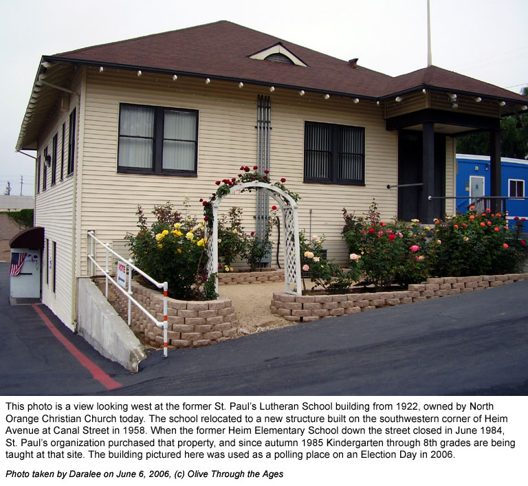
|  St.
Paul's Lutheran Parochial School: The school building, completed
in 1922, showed an address listed as 108 Magnolia Avenue in 1929
and as 8651 Magnolia Avenue in 1958, the year in which the school
relocated to its new site on Heim Avenue in Orange. In 1961, the
address of the school was listed as 16682 Heim, which became 16702
E. Heim by 1965. In autumn 1985, the school relocated again, this
time to the former Heim Elementary School grounds at 901 E. Heim
where it remains today. The wooden structure that once housed
the original parochial school has been renovated and is part of
the North Orange Christian Church facilities. St.
Paul's Lutheran Parochial School: The school building, completed
in 1922, showed an address listed as 108 Magnolia Avenue in 1929
and as 8651 Magnolia Avenue in 1958, the year in which the school
relocated to its new site on Heim Avenue in Orange. In 1961, the
address of the school was listed as 16682 Heim, which became 16702
E. Heim by 1965. In autumn 1985, the school relocated again, this
time to the former Heim Elementary School grounds at 901 E. Heim
where it remains today. The wooden structure that once housed
the original parochial school has been renovated and is part of
the North Orange Christian Church facilities.
[Pictured top right: an image of the school in 1933. Pictured
bottom right: an image of the modified structure in 2006.] |
|
|
| |
|
|
 Presbyterian
Church: This first church in Olive was built in 1898 on the
north side of Hope Street [pictured right in 1899] near North Orange
Christian Church of present times. In 1907, the building was sold
to the newly-formed St. Paul's Lutheran Church organization. Presbyterian
Church: This first church in Olive was built in 1898 on the
north side of Hope Street [pictured right in 1899] near North Orange
Christian Church of present times. In 1907, the building was sold
to the newly-formed St. Paul's Lutheran Church organization. |
|
|
| |
|
|
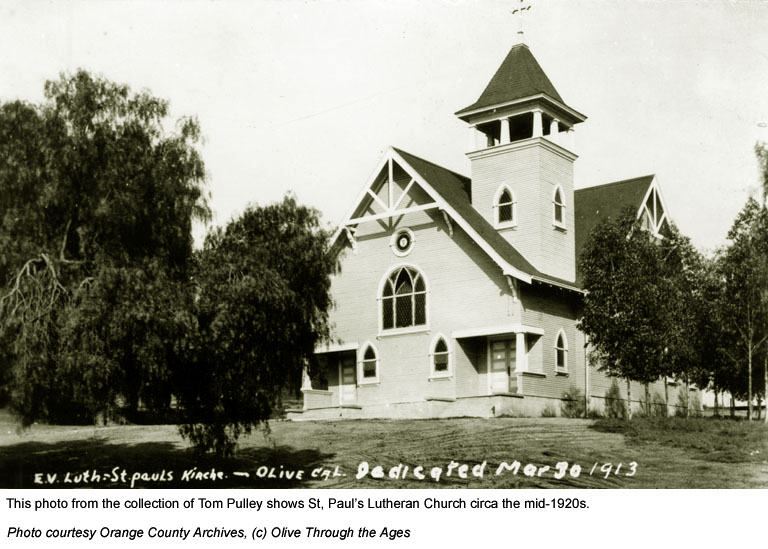
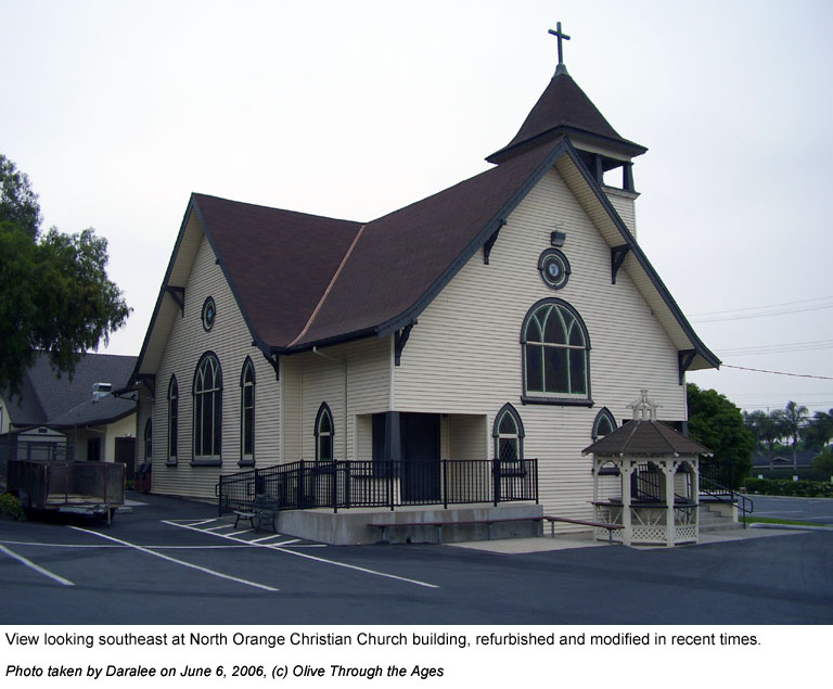
|  St.
Paul's Evangelical Lutheran Church: Founded April 7, 1907,
the wooden sanctuary was completed on the east side of Main Street
in 1913 [see image at top right from circa 1920]. The address
was listed as 108 Magnolia Avenue in 1929 and as 16601 Main in
1958. St.
Paul's Evangelical Lutheran Church: Founded April 7, 1907,
the wooden sanctuary was completed on the east side of Main Street
in 1913 [see image at top right from circa 1920]. The address
was listed as 108 Magnolia Avenue in 1929 and as 16601 Main in
1958.
Tzaddi Wedding Chapel and Metaphysical Center: In 1967,
this organization occupied the former St. Paul's Lutheran Church
sanctuary and remained here a few years. [See 1967
image.]
Olive Heights Wedding Chapel and Reception Hall (Olive Heights
Catering): In 1971, this organization occupied the sanctuary,
listed at 1000 E. Lincoln.
North Orange Christian Church: In 1973, the sanctuary
was purchased by this organization, at the address 1001 E. Lincoln.
The sanctuary [pictured bottom right in 2006] has been renovated
in recent years. [See 1982
image and 2009
image.] |
|
 |
| |
|
|
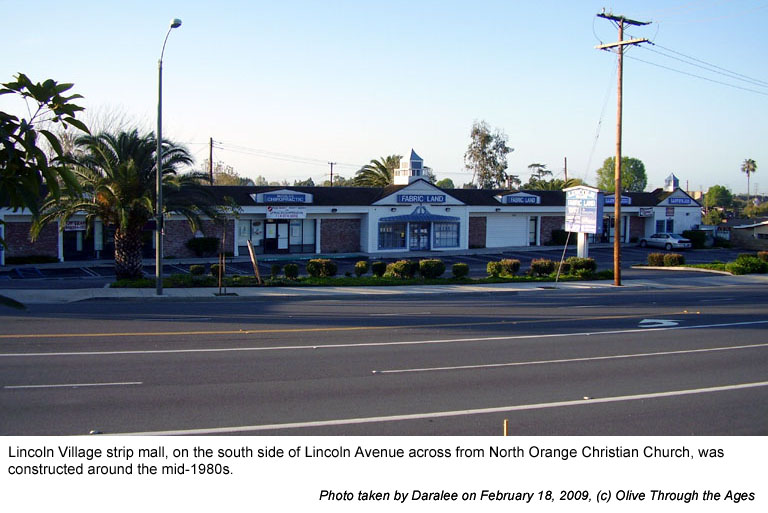
|  Lincoln
Village: Appeared circa the mid-1980s on the south side of
Lincoln Avenue across from present day North Orange Christian
Church [pictured right in 2009]. Fabric Land, pictured in this
photo, closed on December 31, 2019 after having been in business
more than 58 years. Lincoln
Village: Appeared circa the mid-1980s on the south side of
Lincoln Avenue across from present day North Orange Christian
Church [pictured right in 2009]. Fabric Land, pictured in this
photo, closed on December 31, 2019 after having been in business
more than 58 years.
|
|
 |
| |
|
|
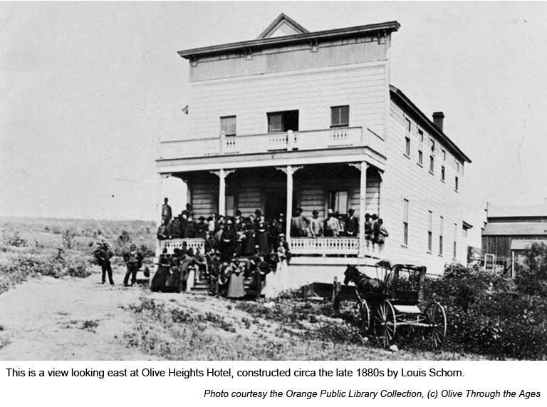
|  Olive
Heights Hotel: Built on 302 Main Street about 1887 [pictured
top right, circa 1888] by Louis Schorn for his employees at the
Olive Milling Company, the hotel would remain in operation until
at least 1934. The structure appears at this location in 1955
and 1959 aerial maps, but does not show up in a 1970 aerial map. Olive
Heights Hotel: Built on 302 Main Street about 1887 [pictured
top right, circa 1888] by Louis Schorn for his employees at the
Olive Milling Company, the hotel would remain in operation until
at least 1934. The structure appears at this location in 1955
and 1959 aerial maps, but does not show up in a 1970 aerial map.
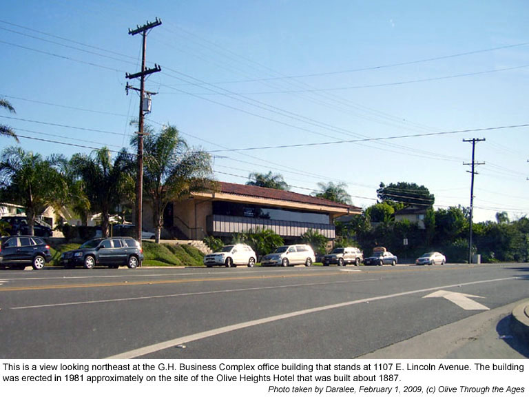
Office Building: In 1981, a two-story stucco office building
was constructed in the approximate area of the hotel. This structure
still stands today at 1107 E. Lincoln Avenue. [Pictured bottom
right in 2009.] |
|
 |
| |
|
|
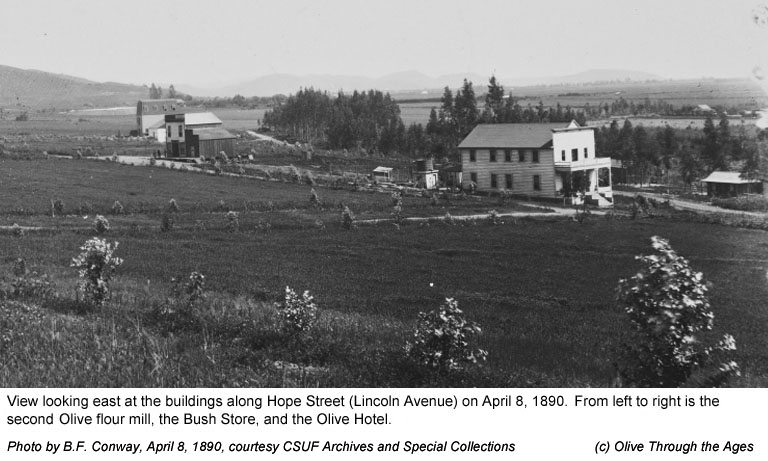
|  Bush
Store: This general store was established around 1888 but
does not appear in the Sanborn Map of 1929. [Pictured right 1890.] Bush
Store: This general store was established around 1888 but
does not appear in the Sanborn Map of 1929. [Pictured right 1890.]
|
|
 |
| |
|
|
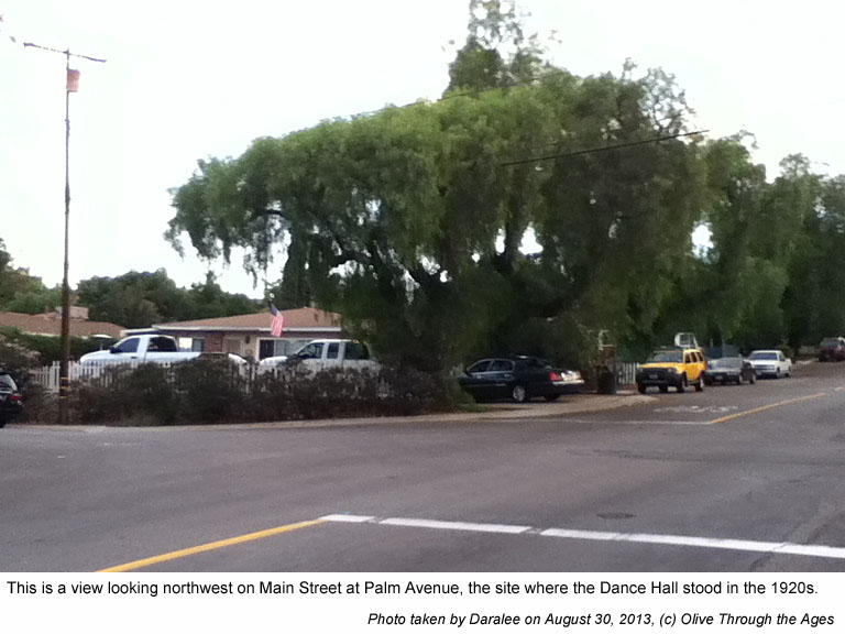
|  Dance
Hall: Located at 315 Main in 1929. Former Olive resident and
author Mildred Yorba MacArthur who passed away in 1987 writes
on page 7 of her pamphlet Recipes of Remembrance: The Brickyard
at Olive Hill, Orange, California: "Another source of
revenue was the Olive Dance Hall, located at the corner of Palm
and Main. Local talent furnished the music." [See 1929
Sanborn Map detail and its site in 2013, pictured at right.] Dance
Hall: Located at 315 Main in 1929. Former Olive resident and
author Mildred Yorba MacArthur who passed away in 1987 writes
on page 7 of her pamphlet Recipes of Remembrance: The Brickyard
at Olive Hill, Orange, California: "Another source of
revenue was the Olive Dance Hall, located at the corner of Palm
and Main. Local talent furnished the music." [See 1929
Sanborn Map detail and its site in 2013, pictured at right.]
|
|
 |
| |
|
|
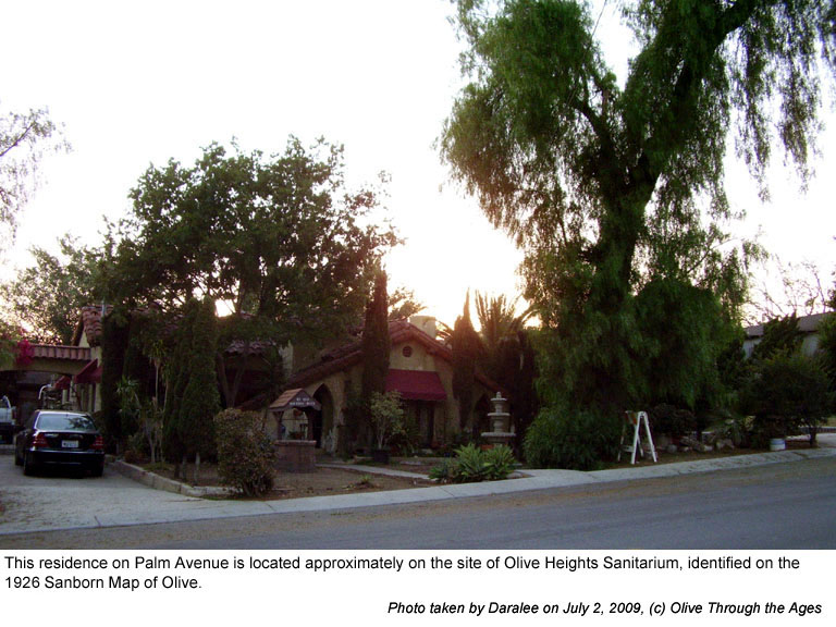
|  Olive
Heights Sanitarium, Inc.: Located at 108 Palm in 1927. [See
1929
Sanborn Map detail and its site in 2009, pictured at right.] Olive
Heights Sanitarium, Inc.: Located at 108 Palm in 1927. [See
1929
Sanborn Map detail and its site in 2009, pictured at right.]
|
|
 |
| |
|
|
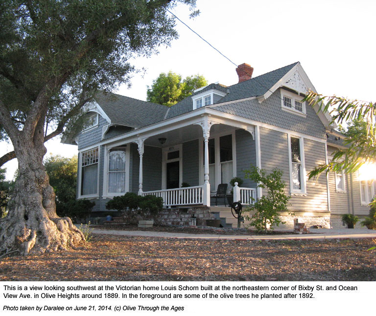
|  Schorn
House: Victorian style home built circa 1889 by Louis Schorn,
one of the owners of the Olive Flour Mill. The house still stands
today on the southeastern corner of 8571 Ocean View Avenue at
Bixby. [Pictured at right in 2014.] Schorn
House: Victorian style home built circa 1889 by Louis Schorn,
one of the owners of the Olive Flour Mill. The house still stands
today on the southeastern corner of 8571 Ocean View Avenue at
Bixby. [Pictured at right in 2014.]
|
|
 |
| |
|
|
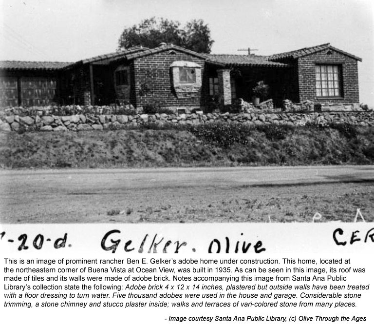
|  Gelker
Adobe: In 1935, citrus rancher Ben Gelker built a single-story
home of adobe bricks from Mission Clay Products Co. brick yard
[see image at right]. The home at 16741 Buena Vista is still at
this site [see image
from 2009.] Gelker
Adobe: In 1935, citrus rancher Ben Gelker built a single-story
home of adobe bricks from Mission Clay Products Co. brick yard
[see image at right]. The home at 16741 Buena Vista is still at
this site [see image
from 2009.]
|
|
 |
| |
|
|
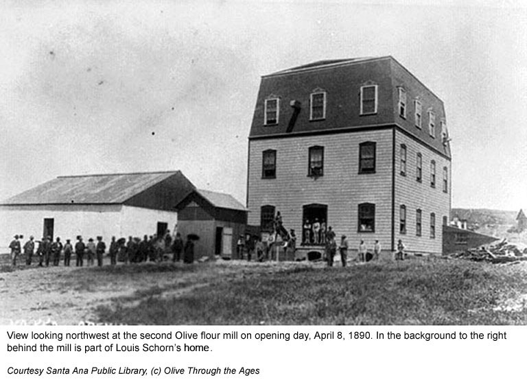
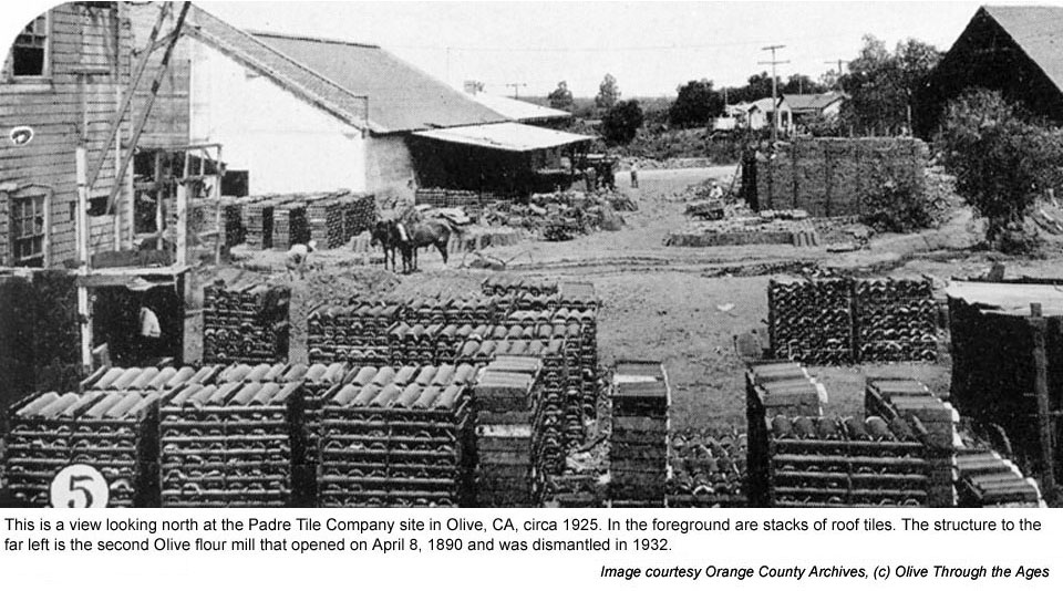
|  Olive
Milling Company: On April 8, 1890 the Olive Flour Mill was
rebuilt southwest of the irrigation pond, with easy access to
the railroad [see image top right]. The operations were sold to
Central
Milling Company on October 1, 1919, and the mill was dismantled
in 1932. Olive
Milling Company: On April 8, 1890 the Olive Flour Mill was
rebuilt southwest of the irrigation pond, with easy access to
the railroad [see image top right]. The operations were sold to
Central
Milling Company on October 1, 1919, and the mill was dismantled
in 1932.
Padre Tile Company: The organization began operating at
this site in 1925 and remained here until circa 1929 [see image
bottom right, and detail from the 1929
Sanborn Map]. The buildings that housed operations appear
on a 1959 aerial photo, but do not show up in a 1970 aerial photo.
Citrus Products, Inc.: This factory canned their "Plus"
brand citrus juices in the old mill and tile company buildings
from 1936 to 1939. [See label
image.]
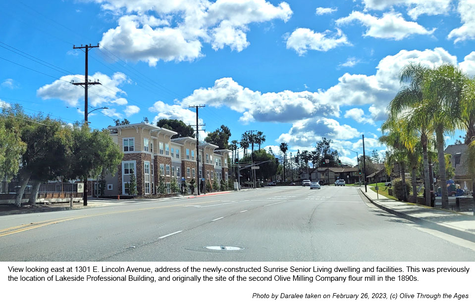
Lakeside Professional Building: This office building opened
at this site in 1972 and remained on the northeastern corner of
Ocean View at 1301 E. Lincoln Avenue until it was demolished on
November 10, 2019. [See 2009
image.]
Sunrise Senior Living: Dwelling units and facilities constructed
on this site are completed before Spring 2023 [pictured bottom
right]. |
|
|
| |
|
|
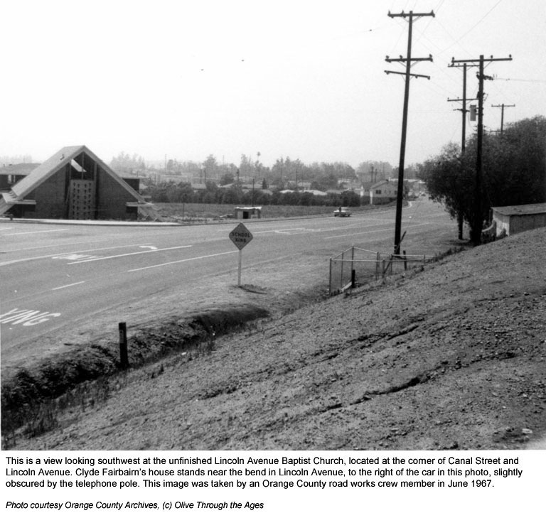
|  Lincoln
Avenue Baptist Church of Orange: In 1962, the Olive Mission
congregation, which was formed by members from the First Southern
Baptist Church of Anaheim, was renting a home on Lincoln Avenue
in Olive to hold their services. In May 1966 they selected the
site at 16751 E. Lincoln Avenue in Olive to build a new sanctuary.
When Lincoln Avenue Baptist Church was completed in 1967 [pictured
at right], the address of this recently annexed property became
1310 E. Lincoln Avenue in the City of Orange. [See
2009 image of the church.] Lincoln
Avenue Baptist Church of Orange: In 1962, the Olive Mission
congregation, which was formed by members from the First Southern
Baptist Church of Anaheim, was renting a home on Lincoln Avenue
in Olive to hold their services. In May 1966 they selected the
site at 16751 E. Lincoln Avenue in Olive to build a new sanctuary.
When Lincoln Avenue Baptist Church was completed in 1967 [pictured
at right], the address of this recently annexed property became
1310 E. Lincoln Avenue in the City of Orange. [See
2009 image of the church.]
In May 2015, Lincoln Avenue Baptist Church was dissolved following
the completion of its merger with The Main Place Christian Fellowship.
The new organization continues to occupy the sanctuary at this
site. |
|
 |
| |
|
|