| Olive
Through the Ages
Click/tap the link (A-K) to go to that
section: Main, B,
C, D,
E, F,
G, H,
I, J,
K
Click/tap A
to return to that section.
_____________________________________________________________________________
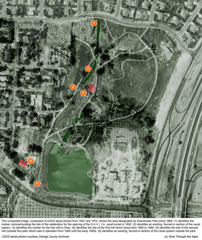
Eisenhower Park, located at 2864 N. Tustin St. in Orange,
CA, was named for U.S. President Dwight Eisenhower who passed away in
1969, the year in which the park was founded. The southwestern section
of the 16.46-acre park includes a manmade lake which, from the 1880s
through the 1950s, functioned as an irrigation pond and reservoir, fed
by water from one of the Santa Ana Valley Irrigation (S.A.V.I.) Company
canals. The canals were originally used to power a three-story, wooden
flour mill,
situated on the western side of the park in 1882. After the structure
burned down in 1889, the mill was rebuilt and reopened in 1890 on a
site adjacent to the park, occupied today by Lakeside Professional Building.
Though the S.A.V.I. Co. canals no longer operate in the park area, portions
of the cement tunnels and canals still remain underground, and some
artifacts from the canal system remain fenced-in on the western side
of the park, as well as in the southwestern-most corner on Lincoln Avenue.
My thanks to Mike Lynaugh for identifying the canal system
artifact sites at Eisenhower Park and submitting photos of them. - Daralee
  
Click the image below to view it larger on a separate
window/tab.
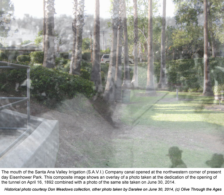
|  Mouth
of the S.A.V.I. Co. Tunnel: On April 14, 1892 a dedication
ceremony for the newly-completed, concrete, Santa Ana Valley Irrigation
Company tunnel was held beside the mouth of the tunnel which was
located at the northwestern-most corner of the park [see composite
image at right showing the 1892 celebration and the site today].
Water from the tunnel powered the first and second flour mills,
the original mill which was located near the northwestern side
of the park [see 2014
photo of the location of the marker designating the site of
the grand opening of the S.A.V.I. Co. tunnel]. Mouth
of the S.A.V.I. Co. Tunnel: On April 14, 1892 a dedication
ceremony for the newly-completed, concrete, Santa Ana Valley Irrigation
Company tunnel was held beside the mouth of the tunnel which was
located at the northwestern-most corner of the park [see composite
image at right showing the 1892 celebration and the site today].
Water from the tunnel powered the first and second flour mills,
the original mill which was located near the northwestern side
of the park [see 2014
photo of the location of the marker designating the site of
the grand opening of the S.A.V.I. Co. tunnel].
|
|
 |
| |
|
|
|  S.A.V.I.
Co. Canal Gate Artifacts: Remnants of the S.A.V.I. Co. canal
system [pictured right in 2014] remain in a fenced-in area on
the northwestern side of the park [see 2014
photo of the site]. These canal gates were used to control
water flowing to the south and to the east. Water from the canal
powered the flour mill and was later used for irrigating the citrus
groves. S.A.V.I.
Co. Canal Gate Artifacts: Remnants of the S.A.V.I. Co. canal
system [pictured right in 2014] remain in a fenced-in area on
the northwestern side of the park [see 2014
photo of the site]. These canal gates were used to control
water flowing to the south and to the east. Water from the canal
powered the flour mill and was later used for irrigating the citrus
groves.
|
|
 |
| |
|
|
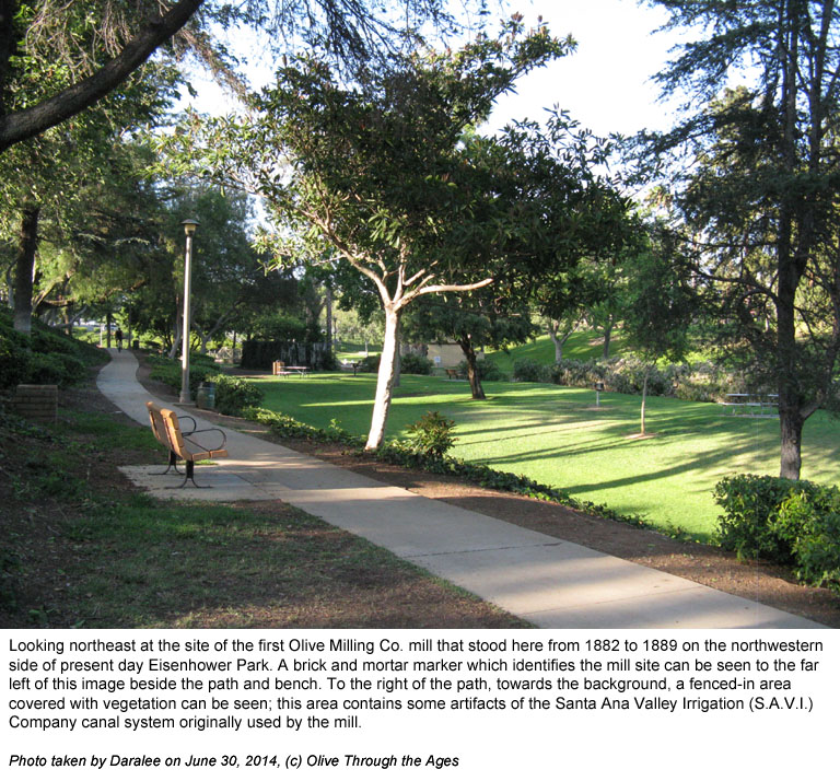
 Site
of Olive Mill Marker: On February 3, 1976, the site of the original
flour mill was marked by a brick monument [pictured right in 2014]
erected by the Orange North Rotary Club alongside a pathway near
the mill site. Site
of Olive Mill Marker: On February 3, 1976, the site of the original
flour mill was marked by a brick monument [pictured right in 2014]
erected by the Orange North Rotary Club alongside a pathway near
the mill site. |
|
 |
| |
|
|
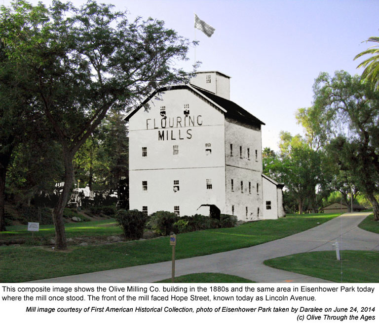
|  The
First Olive Mill: On November 4, 1882, the Dillin (Olive)
Mill [see 1880s
photo of the mill] began operating on the northwestern edge
of the park [see composite image at right and the 2014
photo of the mill site]. The mill burned down on September
29, 1889 and was rebuilt near the southeastern side of the irrigation
pond—the park lake today—approximately at the site
formerly occupied by Lakeside Professional Building. The
First Olive Mill: On November 4, 1882, the Dillin (Olive)
Mill [see 1880s
photo of the mill] began operating on the northwestern edge
of the park [see composite image at right and the 2014
photo of the mill site]. The mill burned down on September
29, 1889 and was rebuilt near the southeastern side of the irrigation
pond—the park lake today—approximately at the site
formerly occupied by Lakeside Professional Building.
|
|
 |
| |
|
|
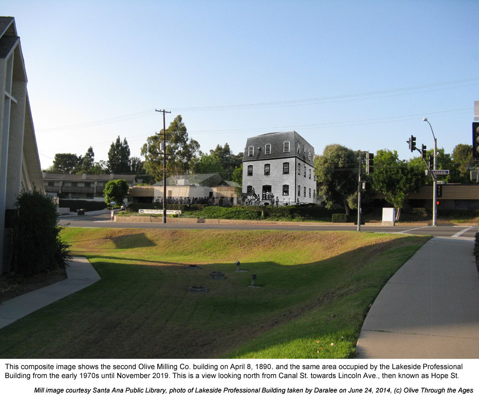
 The
Second Olive Mill: On April 8, 1890 the flour mill was rebuilt
southwest of the irrigation pond, with easy access to the railroad
[see composite image at right and 1890
photo]. The operations were sold to Central Milling Company
on October 1, 1919, and the mill was dismantled in 1932. Lakeside
Professional Building was at this site from 1972 [see 2009
photo] until November 2019. The
Second Olive Mill: On April 8, 1890 the flour mill was rebuilt
southwest of the irrigation pond, with easy access to the railroad
[see composite image at right and 1890
photo]. The operations were sold to Central Milling Company
on October 1, 1919, and the mill was dismantled in 1932. Lakeside
Professional Building was at this site from 1972 [see 2009
photo] until November 2019.
|
|
 |
| |
|
|
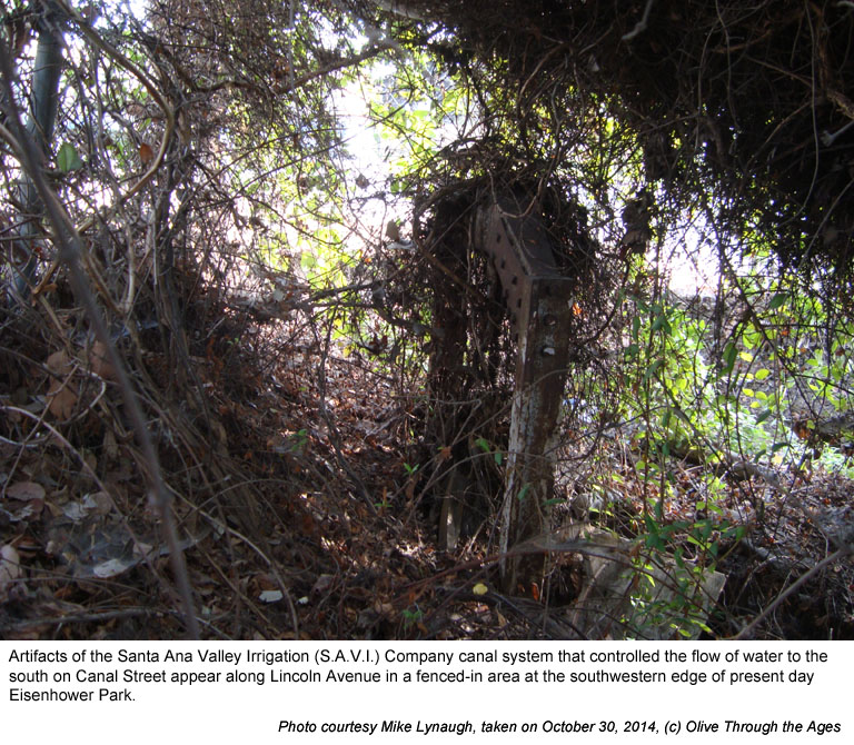
 S.A.V.I.
Co. Canal Gate Artifacts: Remnants of the S.A.V.I. Co. canal
system [pictured right in 2014] remain in a fenced-in area at the
southwestern edge of the park along Lincoln Avenue, next to the
site formerly occupied by the Lakeside Professional Building [see
2009
photo of this site]. This canal gate was used to control water
flowing south towards Canal St. which was used for irrigating the
citrus groves. S.A.V.I.
Co. Canal Gate Artifacts: Remnants of the S.A.V.I. Co. canal
system [pictured right in 2014] remain in a fenced-in area at the
southwestern edge of the park along Lincoln Avenue, next to the
site formerly occupied by the Lakeside Professional Building [see
2009
photo of this site]. This canal gate was used to control water
flowing south towards Canal St. which was used for irrigating the
citrus groves. |
|
 |
| |
|
|
_______________________________________________
Top of page |
Tour index
_______________________________________________
|


